Catane geodata
Catane (Dolj) is a seat of a second-order administrative division; located in Romania in Europe/Bucharest (GMT+3) time zone. In our database, there are 7076 cities with bigger population. Compared to other cities in Romania, 98% of cities are located further ↑North; 78.4% of cities are located further →East and 94.2% of cities have higher elevation than Catane. Note1


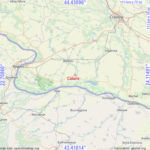
Catane GPS coordinates[2]
43° 55' 36.156" North, 23° 24' 42.408" East
| Map corner | latitude | longitude |
|---|---|---|
| Upper-left | 44.43096°, | 22.70866° |
| Center: | 43.92671°, | 23.41178° |
| Lower-right: | 43.41814°, | 24.11491° |
| Map W x H: | 112.6×112.6 km | = 70×70mi |
| max Lat: | 48.23793° ⇑98% North |
| Catane: | 43.92671° |
| min Lat: | ⇓2% South 43.65638° |
| min Long | Catane | max Long |
| 20.31667° | 23.41178° | 29.65403° |
| W 21.6%⇐ | ⇒78.4% E |
Elevation
Elevation of Catane is 38 m = 125 ft, and this is 216.9 m = 712 ft below average elevation for this country.
| Max E: |
1278 m = 4193 ft | 94.2% |
| Avg. | 254.9 m = 836 ft | |
| Catane | 38 m = 125 ft | |
Min E: |
-2 m = -7 ft | 5.8% |
See also: Romania elevation on elevation.city.
Geographical zone
Catane is located in North temperate zone (between Tropic of Cancer and the Arctic Circle). Distance of this Northern Tropic circle is 2278.3 km =1415.7 mi to South.| Distance of | km | miles | from Catane |
|---|---|---|---|
| North Pole | 5122.9 | 3183.2 | to North |
| Arctic Circle | 2517 | 1564 | to North |
| Tropic Cancer | 2278.3 | 1415.7 | to South |
| Equator | 4884.2 | 3034.9 | to South |


Nearby cities:
15 places around Catane: (largest is in red/bold)
• Afumaţi
9.3 km =5.8 mi,  28°
28°
• Bistreț
7.7 km =4.8 mi,  112°
112°
• Bistrețu Nou
5.6 km =3.5 mi,  120°
120°
• Boureni
10.1 km =6.3 mi,  10°
10°
• Băileşti
11.2 km =7 mi,  333°
333°
• Cioroiu Nou
15.3 km =9.5 mi, 6°
• Covei
5.3 km =3.3 mi, 9°
• Cârna
15.9 km =9.9 mi, 106°
• Goicea
16.4 km =10.2 mi,  93°
93°
• Negoi
3.4 km =2.1 mi,  245°
245°
• Plosca
11.9 km =7.4 mi, 106°
• Rast
11.4 km =7.1 mi,  244°
244°
• Seaca de Câmp
15.6 km =9.7 mi,  272°
272°
• Siliştea Crucii
13.2 km =8.2 mi, 25°
• Urzicuţa
14.9 km =9.3 mi,  47°
47°
Sources, notices
• [Note1] Compared only with cities in Romania existing in our database
• [Src1] Map data: © OpenStreetMap contributors (CC-BY-SA)
• [Src2] Other city data from geonames.org with taken over terms of usage.
• [Src3] Geographical zone / Annual Mean Temperature by Robert A. Rohde @ Wikipedia
