Butoiu geodata
Butoiu (Ialomiţa) is a populated place; located in Romania in Europe/Bucharest (GMT+3) time zone. With population of 842 people, there are 4874 cities with bigger population in this country. Compared to other cities in Romania, 81.6% of cities are located further ↑North; 79.5% of cities are located further ←West and 92.2% of cities have higher elevation than Butoiu. Note1


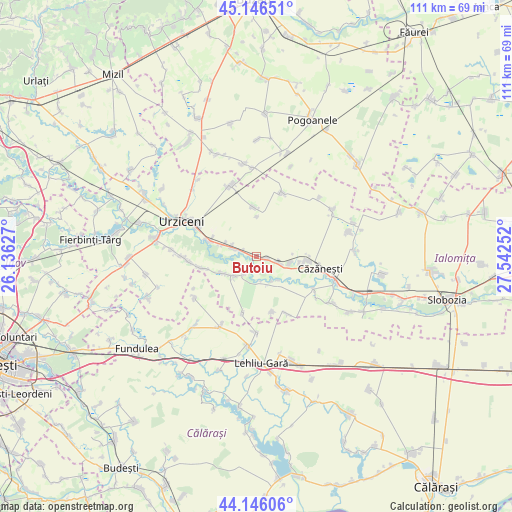
Butoiu GPS coordinates[2]
44° 38' 54.384" North, 26° 50' 21.804" East
| Map corner | latitude | longitude |
|---|---|---|
| Upper-left | 45.14651°, | 26.13627° |
| Center: | 44.64844°, | 26.83939° |
| Lower-right: | 44.14606°, | 27.54252° |
| Map W x H: | 111.2×111.2 km | = 69.1×69.1mi |
| max Lat: | 48.23793° ⇑81.6% North |
| Butoiu: | 44.64844° |
| min Lat: | ⇓18.4% South 43.65638° |
| min Long | Butoiu | max Long |
| 20.31667° | 26.83939° | 29.65403° |
| W 79.5%⇐ | ⇒20.5% E |
Elevation
Elevation of Butoiu is 48 m = 157 ft, and this is 206.9 m = 679 ft below average elevation for this country.
| Max E: |
1278 m = 4193 ft | 92.2% |
| Avg. | 254.9 m = 836 ft | |
| Butoiu | 48 m = 157 ft | |
Min E: |
-2 m = -7 ft | 7.8% |
See also: Romania elevation on elevation.city.
Geographical zone
Butoiu is located in North temperate zone (between Tropic of Cancer and the Arctic Circle). Distance of this Northern Tropic circle is 2358.5 km =1465.5 mi to South.| Distance of | km | miles | from Butoiu |
|---|---|---|---|
| North Pole | 5042.6 | 3133.3 | to North |
| Arctic Circle | 2436.7 | 1514.1 | to North |
| Tropic Cancer | 2358.5 | 1465.5 | to South |
| Equator | 4964.4 | 3084.7 | to South |


Nearby cities:
15 places around Butoiu: (largest is in red/bold)
• Alexeni
11.7 km =7.3 mi,  289°
289°
• Axintele
7 km =4.3 mi,  219°
219°
• Balaciu
3.9 km =2.4 mi,  115°
115°
• Broșteni
7.7 km =4.8 mi, 289°
• Condeești
11.9 km =7.4 mi,  258°
258°
• Grindași
8.8 km =5.5 mi,  0°
0°
• Horia
12.7 km =7.9 mi,  193°
193°
• Ion Roată
6.1 km =3.8 mi, 289°
• Munteni Buzău
11.5 km =7.1 mi,  98°
98°
• Orezu
14.2 km =8.8 mi, 119°
• Rași
14.3 km =8.9 mi,  151°
151°
• Sfântu Gheorghe
0.5 km =0.3 mi, 289°
• Sălcioara
13.3 km =8.3 mi,  164°
164°
• Sărățeni
7.1 km =4.4 mi, 102°
• Valea Măcrișului
10.6 km =6.6 mi,  356°
356°
Sources, notices
• [Note1] Compared only with cities in Romania existing in our database
• [Src1] Map data: © OpenStreetMap contributors (CC-BY-SA)
• [Src2] Other city data from geonames.org with taken over terms of usage.
• [Src3] Geographical zone / Annual Mean Temperature by Robert A. Rohde @ Wikipedia
