Balaciu geodata
Balaciu (Ialomiţa) is a seat of a second-order administrative division; located in Romania in Europe/Bucharest (GMT+3) time zone. With population of 1,069 people, there are 4063 cities with bigger population in this country. Compared to other cities in Romania, 82% of cities are located further ↑North; 80.6% of cities are located further ←West and 94.2% of cities have higher elevation than Balaciu. Note1


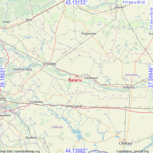
Balaciu GPS coordinates[2]
44° 37' 59.988" North, 26° 52' 59.988" East
| Map corner | latitude | longitude |
|---|---|---|
| Upper-left | 45.13153°, | 26.18021° |
| Center: | 44.63333°, | 26.88333° |
| Lower-right: | 44.13082°, | 27.58646° |
| Map W x H: | 111.3×111.3 km | = 69.2×69.2mi |
| max Lat: | 48.23793° ⇑82% North |
| Balaciu: | 44.63333° |
| min Lat: | ⇓18% South 43.65638° |
| min Long | Balaciu | max Long |
| 20.31667° | 26.88333° | 29.65403° |
| W 80.6%⇐ | ⇒19.4% E |
Elevation
Elevation of Balaciu is 38 m = 125 ft, and this is 216.9 m = 712 ft below average elevation for this country.
| Max E: |
1278 m = 4193 ft | 94.2% |
| Avg. | 254.9 m = 836 ft | |
| Balaciu | 38 m = 125 ft | |
Min E: |
-2 m = -7 ft | 5.8% |
See also: Romania elevation on elevation.city.
Geographical zone
Balaciu is located in North temperate zone (between Tropic of Cancer and the Arctic Circle). Distance of this Northern Tropic circle is 2356.8 km =1464.4 mi to South.| Distance of | km | miles | from Balaciu |
|---|---|---|---|
| North Pole | 5044.3 | 3134.4 | to North |
| Arctic Circle | 2438.4 | 1515.2 | to North |
| Tropic Cancer | 2356.8 | 1464.4 | to South |
| Equator | 4962.8 | 3083.7 | to South |


Nearby cities:
15 places around Balaciu: (largest is in red/bold)
• Axintele
8.7 km =5.4 mi,  244°
244°
• Broșteni
11.5 km =7.1 mi,  291°
291°
• Butoiu
3.9 km =2.4 mi,  295°
295°
• Căzăneşti
10.7 km =6.6 mi,  99°
99°
• Grindași
11 km =6.8 mi,  341°
341°
• Grindu
15.1 km =9.4 mi,  10°
10°
• Horia
12.4 km =7.7 mi,  210°
210°
• Ion Roată
9.9 km =6.2 mi, 291°
• Munteni Buzău
7.9 km =4.9 mi,  90°
90°
• Orezu
10.3 km =6.4 mi,  121°
121°
• Rași
11.4 km =7.1 mi,  163°
163°
• Sfântu Gheorghe
4.4 km =2.7 mi, 295°
• Sălcioara
11.1 km =6.9 mi,  180°
180°
• Sărățeni
3.4 km =2.1 mi, 88°
• Valea Măcrișului
13 km =8.1 mi, 341°
Sources, notices
• [Note1] Compared only with cities in Romania existing in our database
• [Src1] Map data: © OpenStreetMap contributors (CC-BY-SA)
• [Src2] Other city data from geonames.org with taken over terms of usage.
• [Src3] Geographical zone / Annual Mean Temperature by Robert A. Rohde @ Wikipedia
