Buşteni geodata
Buşteni (Prahova) is a seat of a second-order administrative division; located in Romania in Europe/Bucharest (GMT+3) time zone. With population of 9,906 people, there are 221 cities with bigger population in this country. Compared to other cities in Romania, 57% of cities are located further ↑North; 54.9% of cities are located further ←West and 99.3% of cities have lower elevation than Buşteni. Note1


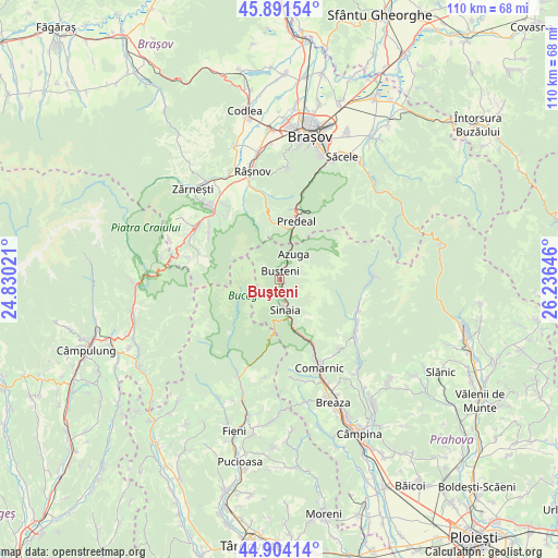
Buşteni GPS coordinates[2]
45° 24' 0" North, 25° 31' 59.988" East
| Map corner | latitude | longitude |
|---|---|---|
| Upper-left | 45.89154°, | 24.83021° |
| Center: | 45.4°, | 25.53333° |
| Lower-right: | 44.90414°, | 26.23646° |
| Map W x H: | 109.8×109.8 km | = 68.2×68.2mi |
| max Lat: | 48.23793° ⇑57% North |
| Buşteni: | 45.4° |
| min Lat: | ⇓43% South 43.65638° |
| min Long | Buşteni | max Long |
| 20.31667° | 25.53333° | 29.65403° |
| W 54.9%⇐ | ⇒45.1% E |
Elevation
Elevation of Buşteni is 900 m = 2953 ft, and this is 645.1 m = 2116 ft above average elevation for this country.
| Max E: |
1278 m = 4193 ft | 0.7% |
| Buşteni | 900 m 2953 ft | |
| Avg. | 254.9 m = 836 ft | |
Min E: |
-2 m = -7 ft | 99.3% |
See also: Romania elevation on elevation.city.
Geographical zone
Buşteni is located in North temperate zone (between Tropic of Cancer and the Arctic Circle). Distance of this North polar circle is 2353.2 km =1462.2 mi to North.| Distance of | km | miles | from Buşteni |
|---|---|---|---|
| North Pole | 4959.1 | 3081.4 | to North |
| Arctic Circle | 2353.2 | 1462.2 | to North |
| Tropic Cancer | 2442.1 | 1517.5 | to South |
| Equator | 5048 | 3136.7 | to South |


Nearby cities:
15 places around Buşteni: (largest is in red/bold)
• Azuga
5.7 km =3.5 mi,  13°
13°
• Comarnic
18.4 km =11.4 mi,  154°
154°
• Fundata
19 km =11.8 mi,  286°
286°
• Ghioșești
19 km =11.8 mi,  157°
157°
• Glod
18.8 km =11.7 mi,  200°
200°
• Moieciu de Sus
16.5 km =10.3 mi, 286°
• Poiana Țapului
0.9 km =0.6 mi,  141°
141°
• Posada
14.2 km =8.8 mi, 151°
• Predeal
11.4 km =7.1 mi, 13°
• Secăria
17.5 km =10.9 mi, 137°
• Sinaia
5.7 km =3.5 mi,  166°
166°
• Sohodol
17.5 km =10.9 mi,  324°
324°
• Teșila
18.3 km =11.4 mi,  125°
125°
• Trăisteni
16.6 km =10.3 mi,  114°
114°
• Șimon
16.7 km =10.4 mi,  304°
304°
Sources, notices
• [Note1] Compared only with cities in Romania existing in our database
• [Src1] Map data: © OpenStreetMap contributors (CC-BY-SA)
• [Src2] Other city data from geonames.org with taken over terms of usage.
• [Src3] Geographical zone / Annual Mean Temperature by Robert A. Rohde @ Wikipedia
