Bârsana geodata
Bârsana (Maramureş) is a seat of a second-order administrative division; located in Romania in Europe/Bucharest (GMT+3) time zone. With population of 6,266 people, there are 500 cities with bigger population in this country. Compared to other cities in Romania, 96.8% of cities are located further ↓South; 68.3% of cities are located further →East and 73.7% of cities have lower elevation than Bârsana. Note1


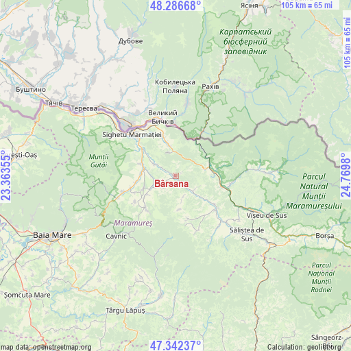
Bârsana GPS coordinates[2]
47° 49' 0.012" North, 24° 4' 0.012" East
| Map corner | latitude | longitude |
|---|---|---|
| Upper-left | 48.28668°, | 23.36355° |
| Center: | 47.81667°, | 24.06667° |
| Lower-right: | 47.34237°, | 24.7698° |
| Map W x H: | 105×105 km | = 65.2×65.2mi |
| max Lat: | 48.23793° ⇑3.2% North |
| Bârsana: | 47.81667° |
| min Lat: | ⇓96.8% South 43.65638° |
| min Long | Bârsana | max Long |
| 20.31667° | 24.06667° | 29.65403° |
| W 31.7%⇐ | ⇒68.3% E |
Elevation
Elevation of Bârsana is 344 m = 1129 ft, and this is 89.1 m = 292 ft above average elevation for this country.
| Max E: |
1278 m = 4193 ft | 26.3% |
| Bârsana | 344 m 1129 ft | |
| Avg. | 254.9 m = 836 ft | |
Min E: |
-2 m = -7 ft | 73.7% |
See also: Romania elevation on elevation.city.
Geographical zone
Bârsana is located in North temperate zone (between Tropic of Cancer and the Arctic Circle). Distance of this North polar circle is 2084.5 km =1295.2 mi to North.| Distance of | km | miles | from Bârsana |
|---|---|---|---|
| North Pole | 4690.3 | 2914.4 | to North |
| Arctic Circle | 2084.5 | 1295.2 | to North |
| Tropic Cancer | 2710.8 | 1684.4 | to South |
| Equator | 5316.7 | 3303.6 | to South |


Nearby cities:
15 places around Bârsana: (largest is in red/bold)
• Berbești
10.5 km =6.5 mi,  289°
289°
• Cornești
7.4 km =4.6 mi,  270°
270°
• Coștiui
7.5 km =4.7 mi,  338°
338°
• Călineşti
8.1 km =5 mi,  243°
243°
• Ferești
8.7 km =5.4 mi,  280°
280°
• Giuleşti
10 km =6.2 mi, 270°
• Nănești
4.8 km =3 mi,  299°
299°
• Ocna Şugatag
10.6 km =6.6 mi,  249°
249°
• Oncești
7.2 km =4.5 mi, 298°
• Rona de Sus
9.3 km =5.8 mi,  352°
352°
• Slătioara
7.1 km =4.4 mi,  163°
163°
• Strâmtura
6.2 km =3.9 mi,  126°
126°
• Sârbi
11 km =6.8 mi, 236°
• Valea Stejarului
8.6 km =5.3 mi,  318°
318°
• Văleni
5.1 km =3.2 mi,  227°
227°
Sources, notices
• [Note1] Compared only with cities in Romania existing in our database
• [Src1] Map data: © OpenStreetMap contributors (CC-BY-SA)
• [Src2] Other city data from geonames.org with taken over terms of usage.
• [Src3] Geographical zone / Annual Mean Temperature by Robert A. Rohde @ Wikipedia
