Strâmtura geodata
Strâmtura (Maramureş) is a seat of a second-order administrative division; located in Romania in Europe/Bucharest (GMT+3) time zone. With population of 4,156 people, there are 1107 cities with bigger population in this country. Compared to other cities in Romania, 96.3% of cities are located further ↓South; 67.3% of cities are located further →East and 83.4% of cities have lower elevation than Strâmtura. Note1


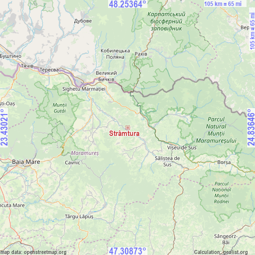
Strâmtura GPS coordinates[2]
47° 46' 59.988" North, 24° 7' 59.988" East
| Map corner | latitude | longitude |
|---|---|---|
| Upper-left | 48.25364°, | 23.43021° |
| Center: | 47.78333°, | 24.13333° |
| Lower-right: | 47.30873°, | 24.83646° |
| Map W x H: | 105.1×105.1 km | = 65.3×65.3mi |
| max Lat: | 48.23793° ⇑3.7% North |
| Strâmtura: | 47.78333° |
| min Lat: | ⇓96.3% South 43.65638° |
| min Long | Strâmtura | max Long |
| 20.31667° | 24.13333° | 29.65403° |
| W 32.7%⇐ | ⇒67.3% E |
Elevation
Elevation of Strâmtura is 428 m = 1404 ft, and this is 173.1 m = 568 ft above average elevation for this country.
| Max E: |
1278 m = 4193 ft | 16.6% |
| Strâmtura | 428 m 1404 ft | |
| Avg. | 254.9 m = 836 ft | |
Min E: |
-2 m = -7 ft | 83.4% |
See also: Romania elevation on elevation.city.
Geographical zone
Strâmtura is located in North temperate zone (between Tropic of Cancer and the Arctic Circle). Distance of this North polar circle is 2088.2 km =1297.5 mi to North.| Distance of | km | miles | from Strâmtura |
|---|---|---|---|
| North Pole | 4694.1 | 2916.8 | to North |
| Arctic Circle | 2088.2 | 1297.5 | to North |
| Tropic Cancer | 2707.1 | 1682.1 | to South |
| Equator | 5313 | 3301.3 | to South |


Nearby cities:
15 places around Strâmtura: (largest is in red/bold)
• Bistra
10.5 km =6.5 mi,  28°
28°
• Botiza
13 km =8.1 mi,  174°
174°
• Bârsana
6.2 km =3.9 mi,  306°
306°
• Cornești
12.9 km =8 mi,  286°
286°
• Crasna Vișeului
8.8 km =5.5 mi,  55°
55°
• Călineşti
12.2 km =7.6 mi,  270°
270°
• Leordina
8.7 km =5.4 mi,  90°
90°
• Nănești
11 km =6.8 mi,  303°
303°
• Petrova
8 km =5 mi,  49°
49°
• Poienile Izei
9.3 km =5.8 mi,  187°
187°
• Rozavlea
8.3 km =5.2 mi,  131°
131°
• Ruscova
11.4 km =7.1 mi,  84°
84°
• Slătioara
4.3 km =2.7 mi,  223°
223°
• Văleni
8.8 km =5.5 mi, 271°
• Șieu
9.4 km =5.8 mi, 133°
Sources, notices
• [Note1] Compared only with cities in Romania existing in our database
• [Src1] Map data: © OpenStreetMap contributors (CC-BY-SA)
• [Src2] Other city data from geonames.org with taken over terms of usage.
• [Src3] Geographical zone / Annual Mean Temperature by Robert A. Rohde @ Wikipedia
