Slătioara geodata
Slătioara (Maramureş) is a populated place; located in Romania in Europe/Bucharest (GMT+3) time zone. With population of 666 people, there are 5775 cities with bigger population in this country. Compared to other cities in Romania, 95.8% of cities are located further ↓South; 67.9% of cities are located further →East and 82% of cities have lower elevation than Slătioara. Note1


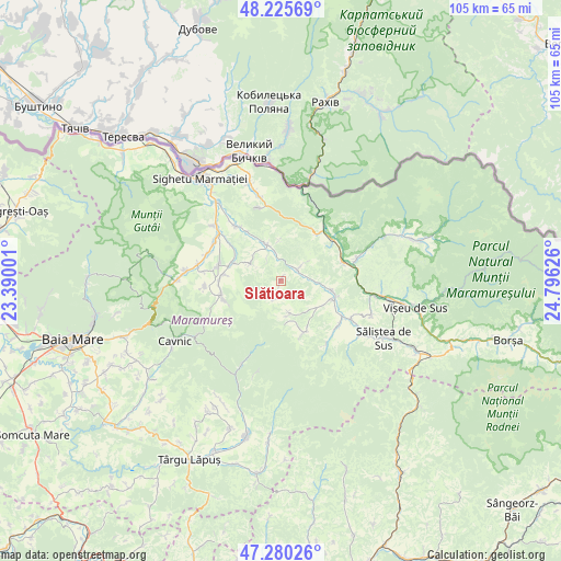
Slătioara GPS coordinates[2]
47° 45' 18.432" North, 24° 5' 35.268" East
| Map corner | latitude | longitude |
|---|---|---|
| Upper-left | 48.22569°, | 23.39001° |
| Center: | 47.75512°, | 24.09313° |
| Lower-right: | 47.28026°, | 24.79626° |
| Map W x H: | 105.1×105.1 km | = 65.3×65.3mi |
| max Lat: | 48.23793° ⇑4.2% North |
| Slătioara: | 47.75512° |
| min Lat: | ⇓95.8% South 43.65638° |
| min Long | Slătioara | max Long |
| 20.31667° | 24.09313° | 29.65403° |
| W 32.1%⇐ | ⇒67.9% E |
Elevation
Elevation of Slătioara is 412 m = 1352 ft, and this is 157.1 m = 515 ft above average elevation for this country.
| Max E: |
1278 m = 4193 ft | 18% |
| Slătioara | 412 m 1352 ft | |
| Avg. | 254.9 m = 836 ft | |
Min E: |
-2 m = -7 ft | 82% |
See also: Romania elevation on elevation.city.
Geographical zone
Slătioara is located in North temperate zone (between Tropic of Cancer and the Arctic Circle). Distance of this North polar circle is 2091.3 km =1299.5 mi to North.| Distance of | km | miles | from Slătioara |
|---|---|---|---|
| North Pole | 4697.2 | 2918.7 | to North |
| Arctic Circle | 2091.3 | 1299.5 | to North |
| Tropic Cancer | 2704 | 1680.2 | to South |
| Equator | 5309.9 | 3299.4 | to South |


Nearby cities:
15 places around Slătioara: (largest is in red/bold)
• Botiza
10.7 km =6.6 mi,  156°
156°
• Budeşti
11 km =6.8 mi,  257°
257°
• Bârsana
7.1 km =4.4 mi,  343°
343°
• Cornești
11.6 km =7.2 mi,  306°
306°
• Călineşti
9.8 km =6.1 mi,  289°
289°
• Leordina
12.1 km =7.5 mi,  75°
75°
• Nănești
11.1 km =6.9 mi,  326°
326°
• Ocna Şugatag
12.3 km =7.6 mi,  284°
284°
• Petrova
12.3 km =7.6 mi,  47°
47°
• Poienile Izei
6.4 km =4 mi, 163°
• Rozavlea
9.5 km =5.9 mi,  104°
104°
• Strâmtura
4.3 km =2.7 mi,  43°
43°
• Sârbi
11.1 km =6.9 mi,  273°
273°
• Văleni
6.7 km =4.2 mi,  300°
300°
• Șieu
10.3 km =6.4 mi,  109°
109°
Sources, notices
• [Note1] Compared only with cities in Romania existing in our database
• [Src1] Map data: © OpenStreetMap contributors (CC-BY-SA)
• [Src2] Other city data from geonames.org with taken over terms of usage.
• [Src3] Geographical zone / Annual Mean Temperature by Robert A. Rohde @ Wikipedia
