Băiţa geodata
Băiţa (Hunedoara) is a seat of a second-order administrative division; located in Romania in Europe/Bucharest (GMT+3) time zone. With population of 4,183 people, there are 1099 cities with bigger population in this country. Compared to other cities in Romania, 55.7% of cities are located further ↓South; 85.9% of cities are located further →East and 63.2% of cities have lower elevation than Băiţa. Note1


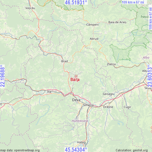
Băiţa GPS coordinates[2]
46° 1' 59.988" North, 22° 54' 0" East
| Map corner | latitude | longitude |
|---|---|---|
| Upper-left | 46.51931°, | 22.19688° |
| Center: | 46.03333°, | 22.9° |
| Lower-right: | 45.54304°, | 23.60313° |
| Map W x H: | 108.6×108.6 km | = 67.5×67.5mi |
| max Lat: | 48.23793° ⇑44.3% North |
| Băiţa: | 46.03333° |
| min Lat: | ⇓55.7% South 43.65638° |
| min Long | Băiţa | max Long |
| 20.31667° | 22.9° | 29.65403° |
| W 14.1%⇐ | ⇒85.9% E |
Elevation
Elevation of Băiţa is 280 m = 919 ft, and this is 25.1 m = 82 ft above average elevation for this country.
| Max E: |
1278 m = 4193 ft | 36.8% |
| Băiţa | 280 m 919 ft | |
| Avg. | 254.9 m = 836 ft | |
Min E: |
-2 m = -7 ft | 63.2% |
See also: Romania elevation on elevation.city.
Geographical zone
Băiţa is located in North temperate zone (between Tropic of Cancer and the Arctic Circle). Distance of this North polar circle is 2282.7 km =1418.4 mi to North.| Distance of | km | miles | from Băiţa |
|---|---|---|---|
| North Pole | 4888.6 | 3037.6 | to North |
| Arctic Circle | 2282.7 | 1418.4 | to North |
| Tropic Cancer | 2512.5 | 1561.2 | to South |
| Equator | 5118.4 | 3180.4 | to South |


Nearby cities:
15 places around Băiţa: (largest is in red/bold)
• Barza
10.2 km =6.3 mi,  340°
340°
• Bucureşci
11.1 km =6.9 mi,  0°
0°
• Bârsău
12.5 km =7.8 mi,  157°
157°
• Certeju de Sus
9 km =5.6 mi,  145°
145°
• Crişcior
9.6 km =6 mi, 344°
• Hondol
8.4 km =5.2 mi,  127°
127°
• Hărțăgani
2.5 km =1.6 mi,  42°
42°
• Luncoiu de Jos
12.7 km =7.9 mi,  305°
305°
• Luncoiu de Sus
8.2 km =5.1 mi, 305°
• Mintia
12.9 km =8 mi,  198°
198°
• Ormindea
3.8 km =2.4 mi, 306°
• Vălişoara
4.3 km =2.7 mi,  295°
295°
• Şoimuş
13 km =8.1 mi,  180°
180°
• Șesuri
7.3 km =4.5 mi,  15°
15°
• Țărățel
11.7 km =7.3 mi,  328°
328°
Sources, notices
• [Note1] Compared only with cities in Romania existing in our database
• [Src1] Map data: © OpenStreetMap contributors (CC-BY-SA)
• [Src2] Other city data from geonames.org with taken over terms of usage.
• [Src3] Geographical zone / Annual Mean Temperature by Robert A. Rohde @ Wikipedia
