Baba Ana geodata
Baba Ana (Prahova) is a seat of a second-order administrative division; located in Romania in Europe/Bucharest (GMT+3) time zone. With population of 4,234 people, there are 1081 cities with bigger population in this country. Compared to other cities in Romania, 71% of cities are located further ↑North; 71.6% of cities are located further ←West and 78.7% of cities have higher elevation than Baba Ana. Note1


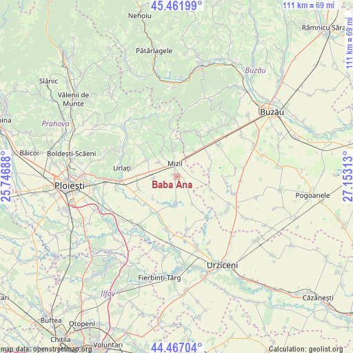
Baba Ana GPS coordinates[2]
44° 58' 0.012" North, 26° 27' 0" East
| Map corner | latitude | longitude |
|---|---|---|
| Upper-left | 45.46199°, | 25.74688° |
| Center: | 44.96667°, | 26.45° |
| Lower-right: | 44.46704°, | 27.15313° |
| Map W x H: | 110.6×110.6 km | = 68.7×68.7mi |
| max Lat: | 48.23793° ⇑71% North |
| Baba Ana: | 44.96667° |
| min Lat: | ⇓29% South 43.65638° |
| min Long | Baba Ana | max Long |
| 20.31667° | 26.45° | 29.65403° |
| W 71.6%⇐ | ⇒28.4% E |
Elevation
Elevation of Baba Ana is 99 m = 325 ft, and this is 155.9 m = 511 ft below average elevation for this country.
| Max E: |
1278 m = 4193 ft | 78.7% |
| Avg. | 254.9 m = 836 ft | |
| Baba Ana | 99 m = 325 ft | |
Min E: |
-2 m = -7 ft | 21.3% |
See also: Romania elevation on elevation.city.
Geographical zone
Baba Ana is located in North temperate zone (between Tropic of Cancer and the Arctic Circle). Distance of this Northern Tropic circle is 2393.9 km =1487.5 mi to South.| Distance of | km | miles | from Baba Ana |
|---|---|---|---|
| North Pole | 5007.2 | 3111.3 | to North |
| Arctic Circle | 2401.3 | 1492.1 | to North |
| Tropic Cancer | 2393.9 | 1487.5 | to South |
| Equator | 4999.8 | 3106.7 | to South |


Nearby cities:
15 places around Baba Ana: (largest is in red/bold)
• Cireșanu
5.1 km =3.2 mi,  72°
72°
• Colceag
8.1 km =5 mi,  256°
256°
• Conduratu
1.4 km =0.9 mi,  296°
296°
• Fefelei
5.2 km =3.2 mi,  352°
352°
• Fulga de Jos
9.5 km =5.9 mi,  183°
183°
• Fulga de Sus
7.4 km =4.6 mi, 180°
• Fântânele
7.3 km =4.5 mi,  308°
308°
• Gura Vadului
9.4 km =5.8 mi,  8°
8°
• Inotești
7.3 km =4.5 mi,  265°
265°
• Mizil
5.6 km =3.5 mi,  0°
0°
• Perșunari
10 km =6.2 mi,  359°
359°
• Săhăteni
9.1 km =5.7 mi,  35°
35°
• Ungureni
9.1 km =5.7 mi,  326°
326°
• Vadu Săpat
9.5 km =5.9 mi, 328°
• Vâlcelele
6.2 km =3.9 mi,  240°
240°
Sources, notices
• [Note1] Compared only with cities in Romania existing in our database
• [Src1] Map data: © OpenStreetMap contributors (CC-BY-SA)
• [Src2] Other city data from geonames.org with taken over terms of usage.
• [Src3] Geographical zone / Annual Mean Temperature by Robert A. Rohde @ Wikipedia
