Fântânele geodata
Fântânele (Prahova) is a seat of a second-order administrative division; located in Romania in Europe/Bucharest (GMT+3) time zone. With population of 2,340 people, there are 2277 cities with bigger population in this country. Compared to other cities in Romania, 69.6% of cities are located further ↑North; 70.4% of cities are located further ←West and 68% of cities have higher elevation than Fântânele. Note1


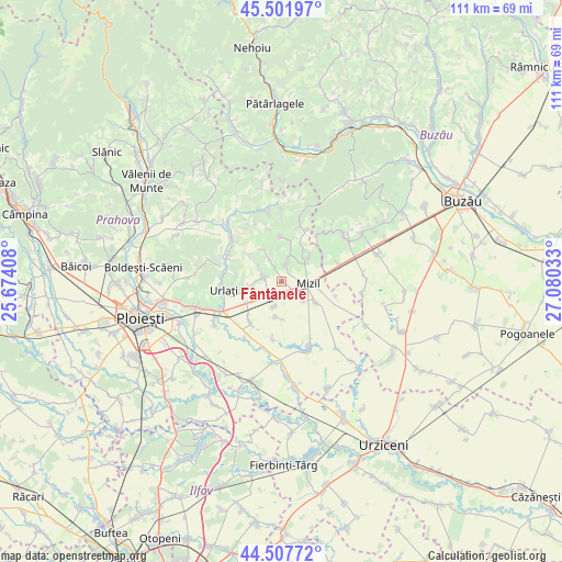
Fântânele GPS coordinates[2]
45° 0' 25.2" North, 26° 22' 37.92" East
| Map corner | latitude | longitude |
|---|---|---|
| Upper-left | 45.50197°, | 25.67408° |
| Center: | 45.007°, | 26.3772° |
| Lower-right: | 44.50772°, | 27.08033° |
| Map W x H: | 110.6×110.5 km | = 68.7×68.7mi |
| max Lat: | 48.23793° ⇑69.6% North |
| Fântânele: | 45.007° |
| min Lat: | ⇓30.4% South 43.65638° |
| min Long | Fântânele | max Long |
| 20.31667° | 26.3772° | 29.65403° |
| W 70.4%⇐ | ⇒29.6% E |
Elevation
Elevation of Fântânele is 135 m = 443 ft, and this is 119.9 m = 393 ft below average elevation for this country.
| Max E: |
1278 m = 4193 ft | 68% |
| Avg. | 254.9 m = 836 ft | |
| Fântânele | 135 m = 443 ft | |
Min E: |
-2 m = -7 ft | 32% |
See also: Romania elevation on elevation.city.
Geographical zone
Fântânele is located in North temperate zone (between Tropic of Cancer and the Arctic Circle). Distance of this North polar circle is 2396.9 km =1489.4 mi to North.| Distance of | km | miles | from Fântânele |
|---|---|---|---|
| North Pole | 5002.8 | 3108.6 | to North |
| Arctic Circle | 2396.9 | 1489.4 | to North |
| Tropic Cancer | 2398.4 | 1490.3 | to South |
| Equator | 5004.3 | 3109.5 | to South |


Nearby cities:
15 places around Fântânele: (largest is in red/bold)
• Baba Ana
7.3 km =4.5 mi,  128°
128°
• Ceptura de Jos
4.2 km =2.6 mi,  291°
291°
• Ceptura de Sus
4.9 km =3 mi,  282°
282°
• Colceag
6.7 km =4.2 mi,  198°
198°
• Conduratu
5.9 km =3.7 mi, 130°
• Fefelei
5.1 km =3.2 mi,  82°
82°
• Inotești
5.3 km =3.3 mi, 196°
• Loloiasca
8 km =5 mi,  237°
237°
• Mizil
5.8 km =3.6 mi, 79°
• Perșunari
7.8 km =4.8 mi,  45°
45°
• Rotari
8.4 km =5.2 mi,  309°
309°
• Ungureni
3.2 km =2 mi,  11°
11°
• Vadu Săpat
3.7 km =2.3 mi, 11°
• Vâlcelele
7.5 km =4.7 mi,  177°
177°
• Șoimești
7.7 km =4.8 mi, 308°
Sources, notices
• [Note1] Compared only with cities in Romania existing in our database
• [Src1] Map data: © OpenStreetMap contributors (CC-BY-SA)
• [Src2] Other city data from geonames.org with taken over terms of usage.
• [Src3] Geographical zone / Annual Mean Temperature by Robert A. Rohde @ Wikipedia
