Almaşu geodata
Almaşu (Sălaj) is a seat of a second-order administrative division; located in Romania in Europe/Bucharest (GMT+3) time zone. With population of 2,801 people, there are 1910 cities with bigger population in this country. Compared to other cities in Romania, 77.7% of cities are located further ↓South; 82.7% of cities are located further →East and 69.1% of cities have lower elevation than Almaşu. Note1


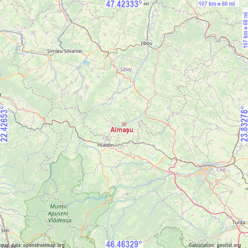
Almaşu GPS coordinates[2]
46° 56' 43.656" North, 23° 7' 46.74" East
| Map corner | latitude | longitude |
|---|---|---|
| Upper-left | 47.42333°, | 22.42653° |
| Center: | 46.94546°, | 23.12965° |
| Lower-right: | 46.46329°, | 23.83278° |
| Map W x H: | 106.7×106.7 km | = 66.3×66.3mi |
| max Lat: | 48.23793° ⇑22.3% North |
| Almaşu: | 46.94546° |
| min Lat: | ⇓77.7% South 43.65638° |
| min Long | Almaşu | max Long |
| 20.31667° | 23.12965° | 29.65403° |
| W 17.3%⇐ | ⇒82.7% E |
Elevation
Elevation of Almaşu is 313 m = 1027 ft, and this is 58.1 m = 191 ft above average elevation for this country.
| Max E: |
1278 m = 4193 ft | 30.9% |
| Almaşu | 313 m 1027 ft | |
| Avg. | 254.9 m = 836 ft | |
Min E: |
-2 m = -7 ft | 69.1% |
See also: Romania elevation on elevation.city.
Geographical zone
Almaşu is located in North temperate zone (between Tropic of Cancer and the Arctic Circle). Distance of this North polar circle is 2181.3 km =1355.4 mi to North.| Distance of | km | miles | from Almaşu |
|---|---|---|---|
| North Pole | 4787.2 | 2974.6 | to North |
| Arctic Circle | 2181.3 | 1355.4 | to North |
| Tropic Cancer | 2613.9 | 1624.2 | to South |
| Equator | 5219.8 | 3243.4 | to South |


Nearby cities:
15 places around Almaşu: (largest is in red/bold)
• Aghireșu
11.6 km =7.2 mi,  134°
134°
• Aghireșu-Fabrici
13.9 km =8.6 mi, 129°
• Agrij
13.7 km =8.5 mi,  350°
350°
• Bicălatu
9.3 km =5.8 mi,  218°
218°
• Buciumi
10.9 km =6.8 mi,  333°
333°
• Cuzăplac
5.8 km =3.6 mi,  66°
66°
• Fildu de Jos
5 km =3.1 mi,  254°
254°
• Fildu de Mijloc
10.4 km =6.5 mi,  256°
256°
• Fildu de Sus
12.7 km =7.9 mi, 263°
• Huedin
10.6 km =6.6 mi,  214°
214°
• Izvoru Crişului
12.7 km =7.9 mi,  190°
190°
• Leghia
11.8 km =7.3 mi,  157°
157°
• Petrindu
5.1 km =3.2 mi,  123°
123°
• Sânmihaiu Almaşului
15.2 km =9.4 mi,  58°
58°
• Zimbor
12 km =7.5 mi, 59°
Sources, notices
• [Note1] Compared only with cities in Romania existing in our database
• [Src1] Map data: © OpenStreetMap contributors (CC-BY-SA)
• [Src2] Other city data from geonames.org with taken over terms of usage.
• [Src3] Geographical zone / Annual Mean Temperature by Robert A. Rohde @ Wikipedia
