Cuzăplac geodata
Cuzăplac (Sălaj) is a seat of a second-order administrative division; located in Romania in Europe/Bucharest (GMT+3) time zone. With population of 1,999 people, there are 2598 cities with bigger population in this country. Compared to other cities in Romania, 78.2% of cities are located further ↓South; 81.5% of cities are located further →East and 63.8% of cities have lower elevation than Cuzăplac. Note1


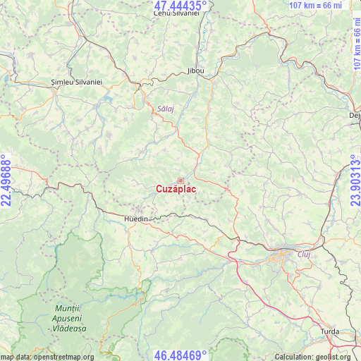
Cuzăplac GPS coordinates[2]
46° 58' 0.012" North, 23° 12' 0" East
| Map corner | latitude | longitude |
|---|---|---|
| Upper-left | 47.44435°, | 22.49688° |
| Center: | 46.96667°, | 23.2° |
| Lower-right: | 46.48469°, | 23.90313° |
| Map W x H: | 106.7×106.7 km | = 66.3×66.3mi |
| max Lat: | 48.23793° ⇑21.8% North |
| Cuzăplac: | 46.96667° |
| min Lat: | ⇓78.2% South 43.65638° |
| min Long | Cuzăplac | max Long |
| 20.31667° | 23.2° | 29.65403° |
| W 18.5%⇐ | ⇒81.5% E |
Elevation
Elevation of Cuzăplac is 283 m = 928 ft, and this is 28.1 m = 92 ft above average elevation for this country.
| Max E: |
1278 m = 4193 ft | 36.2% |
| Cuzăplac | 283 m 928 ft | |
| Avg. | 254.9 m = 836 ft | |
Min E: |
-2 m = -7 ft | 63.8% |
See also: Romania elevation on elevation.city.
Geographical zone
Cuzăplac is located in North temperate zone (between Tropic of Cancer and the Arctic Circle). Distance of this North polar circle is 2179 km =1354 mi to North.| Distance of | km | miles | from Cuzăplac |
|---|---|---|---|
| North Pole | 4784.9 | 2973.2 | to North |
| Arctic Circle | 2179 | 1354 | to North |
| Tropic Cancer | 2616.3 | 1625.7 | to South |
| Equator | 5222.2 | 3244.9 | to South |


Nearby cities:
15 places around Cuzăplac: (largest is in red/bold)
• Aghireșu
10.9 km =6.8 mi,  164°
164°
• Aghireșu-Fabrici
12.3 km =7.6 mi,  153°
153°
• Agrij
13.5 km =8.4 mi,  325°
325°
• Almaşu
5.8 km =3.6 mi,  246°
246°
• Bicălatu
14.7 km =9.1 mi,  229°
229°
• Buciumi
12.5 km =7.8 mi,  306°
306°
• Fildu de Jos
10.8 km =6.7 mi, 249°
• Hida
12.8 km =8 mi,  29°
29°
• Huedin
15.9 km =9.9 mi, 225°
• Leghia
13.3 km =8.3 mi,  183°
183°
• Petrindu
5.3 km =3.3 mi,  192°
192°
• Păușa
13.8 km =8.6 mi,  343°
343°
• Românaşi
14.9 km =9.3 mi,  355°
355°
• Sânmihaiu Almaşului
9.4 km =5.8 mi,  53°
53°
• Zimbor
6.3 km =3.9 mi, 53°
Sources, notices
• [Note1] Compared only with cities in Romania existing in our database
• [Src1] Map data: © OpenStreetMap contributors (CC-BY-SA)
• [Src2] Other city data from geonames.org with taken over terms of usage.
• [Src3] Geographical zone / Annual Mean Temperature by Robert A. Rohde @ Wikipedia
