Buciumi geodata
Buciumi (Sălaj) is a seat of a second-order administrative division; located in Romania in Europe/Bucharest (GMT+3) time zone. With population of 2,776 people, there are 1930 cities with bigger population in this country. Compared to other cities in Romania, 79.7% of cities are located further ↓South; 83.5% of cities are located further →East and 77.8% of cities have lower elevation than Buciumi. Note1


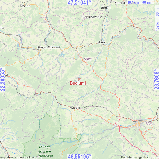
Buciumi GPS coordinates[2]
47° 1' 59.988" North, 23° 4' 0.012" East
| Map corner | latitude | longitude |
|---|---|---|
| Upper-left | 47.51041°, | 22.36355° |
| Center: | 47.03333°, | 23.06667° |
| Lower-right: | 46.55195°, | 23.7698° |
| Map W x H: | 106.6×106.6 km | = 66.2×66.2mi |
| max Lat: | 48.23793° ⇑20.3% North |
| Buciumi: | 47.03333° |
| min Lat: | ⇓79.7% South 43.65638° |
| min Long | Buciumi | max Long |
| 20.31667° | 23.06667° | 29.65403° |
| W 16.5%⇐ | ⇒83.5% E |
Elevation
Elevation of Buciumi is 374 m = 1227 ft, and this is 119.1 m = 391 ft above average elevation for this country.
| Max E: |
1278 m = 4193 ft | 22.2% |
| Buciumi | 374 m 1227 ft | |
| Avg. | 254.9 m = 836 ft | |
Min E: |
-2 m = -7 ft | 77.8% |
See also: Romania elevation on elevation.city.
Geographical zone
Buciumi is located in North temperate zone (between Tropic of Cancer and the Arctic Circle). Distance of this North polar circle is 2171.6 km =1349.4 mi to North.| Distance of | km | miles | from Buciumi |
|---|---|---|---|
| North Pole | 4777.4 | 2968.5 | to North |
| Arctic Circle | 2171.6 | 1349.4 | to North |
| Tropic Cancer | 2623.7 | 1630.3 | to South |
| Equator | 5229.6 | 3249.5 | to South |


Nearby cities:
15 places around Buciumi: (largest is in red/bold)
• Aghireș
14.7 km =9.1 mi,  345°
345°
• Agrij
4.5 km =2.8 mi,  33°
33°
• Almaşu
10.9 km =6.8 mi,  153°
153°
• Cizer
14.4 km =8.9 mi,  284°
284°
• Cuzăplac
12.5 km =7.8 mi,  126°
126°
• Fildu de Jos
11.1 km =6.9 mi,  180°
180°
• Fildu de Mijloc
13.3 km =8.3 mi,  203°
203°
• Fildu de Sus
13.6 km =8.5 mi,  215°
215°
• Meseşenii de Jos
14.4 km =8.9 mi,  334°
334°
• Meseșenii de Sus
12.1 km =7.5 mi, 329°
• Pria
13.5 km =8.4 mi, 277°
• Păușa
8.5 km =5.3 mi,  46°
46°
• Românaşi
11.5 km =7.1 mi, 50°
• Stârciu
12.6 km =7.8 mi,  298°
298°
• Treznea
8.3 km =5.2 mi, 27°
Sources, notices
• [Note1] Compared only with cities in Romania existing in our database
• [Src1] Map data: © OpenStreetMap contributors (CC-BY-SA)
• [Src2] Other city data from geonames.org with taken over terms of usage.
• [Src3] Geographical zone / Annual Mean Temperature by Robert A. Rohde @ Wikipedia
