Srbobran geodata
Srbobran (Vojvodina) is a seat of a third-order administrative division; located in Serbia in Europe/Belgrade (GMT+2) time zone. In our database, there are 365 cities with bigger population. Compared to other cities in Serbia, 87.1% of cities are located further ↓South; 73.5% of cities are located further →East and 84.8% of cities have higher elevation than Srbobran. Note1


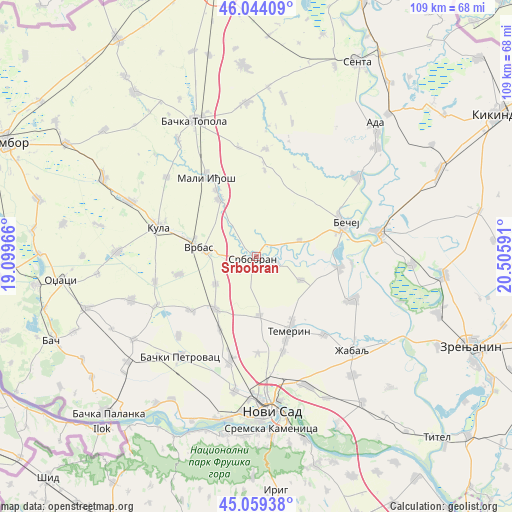
Srbobran GPS coordinates[2]
45° 33' 14.004" North, 19° 48' 10.008" East
| Map corner | latitude | longitude |
|---|---|---|
| Upper-left | 46.04409°, | 19.09966° |
| Center: | 45.55389°, | 19.80278° |
| Lower-right: | 45.05938°, | 20.50591° |
| Map W x H: | 109.5×109.5 km | = 68×68mi |
| max Lat: | 46.1° ⇑12.9% North |
| Srbobran: | 45.55389° |
| min Lat: | ⇓87.1% South 42.25846° |
| min Long | Srbobran | max Long |
| 18.9276° | 19.80278° | 22.77556° |
| W 26.5%⇐ | ⇒73.5% E |
Elevation
Elevation of Srbobran is 77 m = 253 ft, and this is 99.4 m = 326 ft below average elevation for this country.
| Max E: |
1421 m = 4662 ft | 84.8% |
| Avg. | 176.4 m = 579 ft | |
| Srbobran | 77 m = 253 ft | |
Min E: |
49 m = 161 ft | 15.2% |
See also: Serbia elevation on elevation.city.
Geographical zone
Srbobran is located in North temperate zone (between Tropic of Cancer and the Arctic Circle). Distance of this North polar circle is 2336.1 km =1451.6 mi to North.| Distance of | km | miles | from Srbobran |
|---|---|---|---|
| North Pole | 4941.9 | 3070.8 | to North |
| Arctic Circle | 2336.1 | 1451.6 | to North |
| Tropic Cancer | 2459.2 | 1528.1 | to South |
| Equator | 5065.1 | 3147.3 | to South |


Nearby cities:
15 places around Srbobran: (largest is in red/bold)
• Bački Petrovac
27.1 km =16.8 mi,  217°
217°
• Bačko Gradište
17.9 km =11.1 mi,  97°
97°
• Bečej
19.2 km =11.9 mi,  68°
68°
• Despotovo
23.9 km =14.9 mi,  244°
244°
• Kisač
22.9 km =14.2 mi,  194°
194°
• Kula
22.4 km =13.9 mi,  285°
285°
• Kulpin
23.7 km =14.7 mi, 224°
• Mali Iđoš
20.2 km =12.6 mi,  328°
328°
• Novi Bečej
26.4 km =16.4 mi,  79°
79°
• Ravno Selo
18.3 km =11.4 mi,  230°
230°
• Stepanovićevo
17.5 km =10.9 mi,  207°
207°
• Temerin
17.5 km =10.9 mi,  157°
157°
• Vrbas
12.8 km =8 mi,  278°
278°
• Zmajevo
14.1 km =8.8 mi, 218°
• Čurug
22.6 km =14 mi,  113°
113°
Sources, notices
• [Note1] Compared only with cities in Serbia existing in our database
• [Src1] Map data: © OpenStreetMap contributors (CC-BY-SA)
• [Src2] Other city data from geonames.org with taken over terms of usage.
• [Src3] Geographical zone / Annual Mean Temperature by Robert A. Rohde @ Wikipedia
