Bečej geodata
Bečej (Vojvodina) is a seat of a third-order administrative division; located in Serbia in Europe/Belgrade (GMT+2) time zone. With population of 25,774 people, there are 34 cities with bigger population in this country. Compared to other cities in Serbia, 89.6% of cities are located further ↓South; 67.3% of cities are located further →East and 84.8% of cities have higher elevation than Bečej. Note1


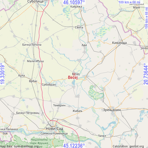
Bečej GPS coordinates[2]
45° 36' 58.752" North, 20° 1' 59.916" East
| Map corner | latitude | longitude |
|---|---|---|
| Upper-left | 46.10597°, | 19.33019° |
| Center: | 45.61632°, | 20.03331° |
| Lower-right: | 45.12236°, | 20.73644° |
| Map W x H: | 109.4×109.4 km | = 68×68mi |
| max Lat: | 46.1° ⇑10.4% North |
| Bečej: | 45.61632° |
| min Lat: | ⇓89.6% South 42.25846° |
| min Long | Bečej | max Long |
| 18.9276° | 20.03331° | 22.77556° |
| W 32.7%⇐ | ⇒67.3% E |
Elevation
Elevation of Bečej is 77 m = 253 ft, and this is 99.4 m = 326 ft below average elevation for this country.
| Max E: |
1421 m = 4662 ft | 84.8% |
| Avg. | 176.4 m = 579 ft | |
| Bečej | 77 m = 253 ft | |
Min E: |
49 m = 161 ft | 15.2% |
See also: Serbia elevation on elevation.city.
Geographical zone
Bečej is located in North temperate zone (between Tropic of Cancer and the Arctic Circle). Distance of this North polar circle is 2329.1 km =1447.2 mi to North.| Distance of | km | miles | from Bečej |
|---|---|---|---|
| North Pole | 4935 | 3066.5 | to North |
| Arctic Circle | 2329.1 | 1447.2 | to North |
| Tropic Cancer | 2466.1 | 1532.4 | to South |
| Equator | 5072.1 | 3151.7 | to South |


Nearby cities:
15 places around Bečej: (largest is in red/bold)
• Ada
21.9 km =13.6 mi,  19°
19°
• Bačko Gradište
9.3 km =5.8 mi,  181°
181°
• Bačko Petrovo Selo
10.7 km =6.6 mi, 19°
• Bočar
25.9 km =16.1 mi,  48°
48°
• Kumane
17.5 km =10.9 mi,  119°
119°
• Melenci
24.9 km =15.5 mi, 116°
• Mol
18.2 km =11.3 mi,  25°
25°
• Novi Bečej
8.2 km =5.1 mi,  103°
103°
• Novo Miloševo
23.9 km =14.9 mi,  61°
61°
• Padej
25.5 km =15.8 mi, 23°
• Srbobran
19.2 km =11.9 mi,  248°
248°
• Taraš
21 km =13 mi,  142°
142°
• Temerin
25.7 km =16 mi,  205°
205°
• Čurug
16.3 km =10.1 mi,  170°
170°
• Žabalj
27.2 km =16.9 mi, 174°
Sources, notices
• [Note1] Compared only with cities in Serbia existing in our database
• [Src1] Map data: © OpenStreetMap contributors (CC-BY-SA)
• [Src2] Other city data from geonames.org with taken over terms of usage.
• [Src3] Geographical zone / Annual Mean Temperature by Robert A. Rohde @ Wikipedia
