Kula geodata
Kula (Vojvodina) is a seat of a third-order administrative division; located in Serbia in Europe/Belgrade (GMT+2) time zone. In our database, there are 365 cities with bigger population. Compared to other cities in Serbia, 89.3% of cities are located further ↓South; 87.1% of cities are located further →East and 67.1% of cities have higher elevation than Kula. Note1


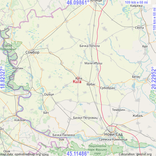
Kula GPS coordinates[2]
45° 36' 32.004" North, 19° 31' 35.004" East
| Map corner | latitude | longitude |
|---|---|---|
| Upper-left | 46.09861°, | 18.82327° |
| Center: | 45.60889°, | 19.52639° |
| Lower-right: | 45.11486°, | 20.22952° |
| Map W x H: | 109.4×109.4 km | = 68×68mi |
| max Lat: | 46.1° ⇑10.7% North |
| Kula: | 45.60889° |
| min Lat: | ⇓89.3% South 42.25846° |
| min Long | Kula | max Long |
| 18.9276° | 19.52639° | 22.77556° |
| W 12.9%⇐ | ⇒87.1% E |
Elevation
Elevation of Kula is 80 m = 262 ft, and this is 96.4 m = 316 ft below average elevation for this country.
| Max E: |
1421 m = 4662 ft | 67.1% |
| Avg. | 176.4 m = 579 ft | |
| Kula | 80 m = 262 ft | |
Min E: |
49 m = 161 ft | 32.9% |
See also: Serbia elevation on elevation.city.
Geographical zone
Kula is located in North temperate zone (between Tropic of Cancer and the Arctic Circle). Distance of this North polar circle is 2329.9 km =1447.7 mi to North.| Distance of | km | miles | from Kula |
|---|---|---|---|
| North Pole | 4935.8 | 3067 | to North |
| Arctic Circle | 2329.9 | 1447.7 | to North |
| Tropic Cancer | 2465.3 | 1531.9 | to South |
| Equator | 5071.2 | 3151.1 | to South |


Nearby cities:
15 places around Kula: (largest is in red/bold)
• Bačka Topola
24.4 km =15.2 mi,  19°
19°
• Bački Petrovac
28.1 km =17.5 mi,  169°
169°
• Bogojevo
32.1 km =19.9 mi,  254°
254°
• Despotovo
16.6 km =10.3 mi,  179°
179°
• Doroslovo
26.3 km =16.3 mi,  269°
269°
• Kisač
32.5 km =20.2 mi,  150°
150°
• Kulpin
23.5 km =14.6 mi, 168°
• Maglić
27.4 km =17 mi, 179°
• Mali Iđoš
15.5 km =9.6 mi,  44°
44°
• Odžaci
23.6 km =14.7 mi,  241°
241°
• Ravno Selo
19.2 km =11.9 mi,  157°
157°
• Srbobran
22.4 km =13.9 mi,  105°
105°
• Stepanovićevo
25.6 km =15.9 mi, 148°
• Vrbas
9.8 km =6.1 mi,  115°
115°
• Zmajevo
21.4 km =13.3 mi,  143°
143°
Sources, notices
• [Note1] Compared only with cities in Serbia existing in our database
• [Src1] Map data: © OpenStreetMap contributors (CC-BY-SA)
• [Src2] Other city data from geonames.org with taken over terms of usage.
• [Src3] Geographical zone / Annual Mean Temperature by Robert A. Rohde @ Wikipedia
