Petrovaradin geodata
Petrovaradin (Vojvodina) is a seat of a third-order administrative division; located in Serbia in Europe/Belgrade (GMT+2) time zone. With population of 13,917 people, there are 49 cities with bigger population in this country. Compared to other cities in Serbia, 72.6% of cities are located further ↓South; 70.3% of cities are located further →East and 78.9% of cities have higher elevation than Petrovaradin. Note1


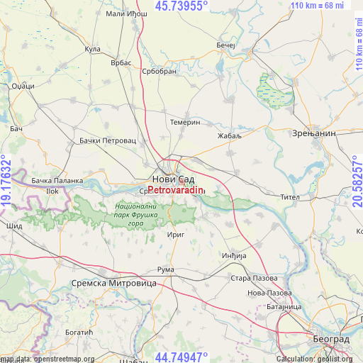
Petrovaradin GPS coordinates[2]
45° 14' 48.012" North, 19° 52' 45.984" East
| Map corner | latitude | longitude |
|---|---|---|
| Upper-left | 45.73955°, | 19.17632° |
| Center: | 45.24667°, | 19.87944° |
| Lower-right: | 44.74947°, | 20.58257° |
| Map W x H: | 110.1×110.1 km | = 68.4×68.4mi |
| max Lat: | 46.1° ⇑27.4% North |
| Petrovaradin: | 45.24667° |
| min Lat: | ⇓72.6% South 42.25846° |
| min Long | Petrovaradin | max Long |
| 18.9276° | 19.87944° | 22.77556° |
| W 29.7%⇐ | ⇒70.3% E |
Elevation
Elevation of Petrovaradin is 78 m = 256 ft, and this is 98.4 m = 323 ft below average elevation for this country.
| Max E: |
1421 m = 4662 ft | 78.9% |
| Avg. | 176.4 m = 579 ft | |
| Petrovaradin | 78 m = 256 ft | |
Min E: |
49 m = 161 ft | 21.1% |
See also: Serbia elevation on elevation.city.
Geographical zone
Petrovaradin is located in North temperate zone (between Tropic of Cancer and the Arctic Circle). Distance of this North polar circle is 2370.2 km =1472.8 mi to North.| Distance of | km | miles | from Petrovaradin |
|---|---|---|---|
| North Pole | 4976.1 | 3092 | to North |
| Arctic Circle | 2370.2 | 1472.8 | to North |
| Tropic Cancer | 2425 | 1506.8 | to South |
| Equator | 5031 | 3126.1 | to South |


Nearby cities:
15 places around Petrovaradin: (largest is in red/bold)
• Beočin
13.1 km =8.1 mi,  251°
251°
• Beška
19.5 km =12.1 mi,  131°
131°
• Irig
16.3 km =10.1 mi,  185°
185°
• Kisač
16.7 km =10.4 mi,  315°
315°
• Kovilj
11.3 km =7 mi,  97°
97°
• Novi Sad
3.4 km =2.1 mi,  279°
279°
• Rumenka
11.9 km =7.4 mi,  296°
296°
• Sremski Karlovci
6.5 km =4 mi,  138°
138°
• Temerin
18 km =11.2 mi,  2°
2°
• Veternik
9.5 km =5.9 mi, 275°
• Vrdnik
15.5 km =9.6 mi,  206°
206°
• Ðurđevo
17 km =10.6 mi,  58°
58°
• Čortanovci
15 km =9.3 mi, 133°
• Šajkaš
16.8 km =10.4 mi,  79°
79°
• Žabalj
20.1 km =12.5 mi,  45°
45°
Sources, notices
• [Note1] Compared only with cities in Serbia existing in our database
• [Src1] Map data: © OpenStreetMap contributors (CC-BY-SA)
• [Src2] Other city data from geonames.org with taken over terms of usage.
• [Src3] Geographical zone / Annual Mean Temperature by Robert A. Rohde @ Wikipedia
