Irig geodata
Irig (Vojvodina) is a seat of a third-order administrative division; located in Serbia in Europe/Belgrade (GMT+2) time zone. In our database, there are 365 cities with bigger population. Compared to other cities in Serbia, 63% of cities are located further ↓South; 71% of cities are located further →East and 74.6% of cities have lower elevation than Irig. Note1


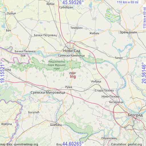
Irig GPS coordinates[2]
45° 6' 3.996" North, 19° 51' 29.988" East
| Map corner | latitude | longitude |
|---|---|---|
| Upper-left | 45.59526°, | 19.15521° |
| Center: | 45.10111°, | 19.85833° |
| Lower-right: | 44.60265°, | 20.56146° |
| Map W x H: | 110.4×110.4 km | = 68.6×68.6mi |
| max Lat: | 46.1° ⇑37% North |
| Irig: | 45.10111° |
| min Lat: | ⇓63% South 42.25846° |
| min Long | Irig | max Long |
| 18.9276° | 19.85833° | 22.77556° |
| W 29%⇐ | ⇒71% E |
Elevation
Elevation of Irig is 185 m = 607 ft, and this is 8.6 m = 28 ft above average elevation for this country.
| Max E: |
1421 m = 4662 ft | 25.4% |
| Irig | 185 m 607 ft | |
| Avg. | 176.4 m = 579 ft | |
Min E: |
49 m = 161 ft | 74.6% |
See also: Serbia elevation on elevation.city.
Geographical zone
Irig is located in North temperate zone (between Tropic of Cancer and the Arctic Circle). Distance of this North polar circle is 2386.4 km =1482.8 mi to North.| Distance of | km | miles | from Irig |
|---|---|---|---|
| North Pole | 4992.3 | 3102.1 | to North |
| Arctic Circle | 2386.4 | 1482.8 | to North |
| Tropic Cancer | 2408.9 | 1496.8 | to South |
| Equator | 5014.8 | 3116.1 | to South |


Nearby cities:
15 places around Irig: (largest is in red/bold)
• Beočin
16.1 km =10 mi,  317°
317°
• Beška
16.7 km =10.4 mi,  78°
78°
• Inđija
18.5 km =11.5 mi,  108°
108°
• Irig
5.5 km =3.4 mi,  191°
191°
• Kovilj
19.7 km =12.2 mi,  41°
41°
• Ljukovo
15.7 km =9.8 mi,  122°
122°
• Novi Sad
16.8 km =10.4 mi,  354°
354°
• Petrovaradin
16.3 km =10.1 mi,  5°
5°
• Putinci
15 km =9.3 mi,  143°
143°
• Ruma
10.7 km =6.6 mi,  195°
195°
• Sremski Karlovci
12.8 km =8 mi,  27°
27°
• Veternik
18.8 km =11.7 mi,  335°
335°
• Vrdnik
5.7 km =3.5 mi,  293°
293°
• Čortanovci
13.9 km =8.6 mi,  64°
64°
• Šašinci
17.7 km =11 mi,  211°
211°
Sources, notices
• [Note1] Compared only with cities in Serbia existing in our database
• [Src1] Map data: © OpenStreetMap contributors (CC-BY-SA)
• [Src2] Other city data from geonames.org with taken over terms of usage.
• [Src3] Geographical zone / Annual Mean Temperature by Robert A. Rohde @ Wikipedia
