Vilovo geodata
Vilovo (Vojvodina) is a populated place; located in Serbia in Europe/Belgrade (GMT+2) time zone. With population of 1,089 people, there are 308 cities with bigger population in this country. Compared to other cities in Serbia, 72.8% of cities are located further ↓South; 60.5% of cities are located further →East and 96.4% of cities have higher elevation than Vilovo. Note1


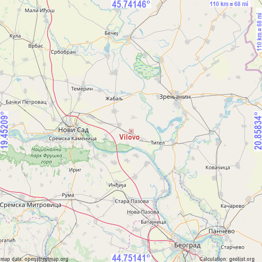
Vilovo GPS coordinates[2]
45° 14' 54.924" North, 20° 9' 18.756" East
| Map corner | latitude | longitude |
|---|---|---|
| Upper-left | 45.74146°, | 19.45209° |
| Center: | 45.24859°, | 20.15521° |
| Lower-right: | 44.75141°, | 20.85834° |
| Map W x H: | 110.1×110.1 km | = 68.4×68.4mi |
| max Lat: | 46.1° ⇑27.2% North |
| Vilovo: | 45.24859° |
| min Lat: | ⇓72.8% South 42.25846° |
| min Long | Vilovo | max Long |
| 18.9276° | 20.15521° | 22.77556° |
| W 39.5%⇐ | ⇒60.5% E |
Elevation
Elevation of Vilovo is 74 m = 243 ft, and this is 102.4 m = 336 ft below average elevation for this country.
| Max E: |
1421 m = 4662 ft | 96.4% |
| Avg. | 176.4 m = 579 ft | |
| Vilovo | 74 m = 243 ft | |
Min E: |
49 m = 161 ft | 3.6% |
See also: Serbia elevation on elevation.city.
Geographical zone
Vilovo is located in North temperate zone (between Tropic of Cancer and the Arctic Circle). Distance of this North polar circle is 2370 km =1472.6 mi to North.| Distance of | km | miles | from Vilovo |
|---|---|---|---|
| North Pole | 4975.9 | 3091.9 | to North |
| Arctic Circle | 2370 | 1472.6 | to North |
| Tropic Cancer | 2425.3 | 1507 | to South |
| Equator | 5031.2 | 3126.2 | to South |


Nearby cities:
15 places around Vilovo: (largest is in red/bold)
• Belo Blato
17.4 km =10.8 mi,  81°
81°
• Beška
14.8 km =9.2 mi,  207°
207°
• Gardinovci
5.2 km =3.2 mi,  197°
197°
• Knićanin
14.6 km =9.1 mi,  118°
118°
• Kovilj
10.5 km =6.5 mi,  261°
261°
• Krčedin
12.3 km =7.6 mi,  188°
188°
• Lok
5.8 km =3.6 mi,  129°
129°
• Mošorin
6 km =3.7 mi,  10°
10°
• Novi Slankamen
15.2 km =9.4 mi,  154°
154°
• Stari Slankamen
14.3 km =8.9 mi, 145°
• Titel
11.9 km =7.4 mi,  113°
113°
• Ðurđevo
11.1 km =6.9 mi,  320°
320°
• Čortanovci
15 km =9.3 mi,  225°
225°
• Šajkaš
5.8 km =3.6 mi,  298°
298°
• Žabalj
15.5 km =9.6 mi,  332°
332°
Sources, notices
• [Note1] Compared only with cities in Serbia existing in our database
• [Src1] Map data: © OpenStreetMap contributors (CC-BY-SA)
• [Src2] Other city data from geonames.org with taken over terms of usage.
• [Src3] Geographical zone / Annual Mean Temperature by Robert A. Rohde @ Wikipedia
