Mošorin geodata
Mošorin (Vojvodina) is a populated place; located in Serbia in Europe/Belgrade (GMT+2) time zone. With population of 2,483 people, there are 179 cities with bigger population in this country. Compared to other cities in Serbia, 76.6% of cities are located further ↓South; 59.2% of cities are located further →East and 94.6% of cities have higher elevation than Mošorin. Note1


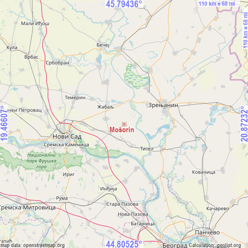
Mošorin GPS coordinates[2]
45° 18' 7.056" North, 20° 10' 9.084" East
| Map corner | latitude | longitude |
|---|---|---|
| Upper-left | 45.79436°, | 19.46607° |
| Center: | 45.30196°, | 20.16919° |
| Lower-right: | 44.80525°, | 20.87232° |
| Map W x H: | 110×110 km | = 68.4×68.4mi |
| max Lat: | 46.1° ⇑23.4% North |
| Mošorin: | 45.30196° |
| min Lat: | ⇓76.6% South 42.25846° |
| min Long | Mošorin | max Long |
| 18.9276° | 20.16919° | 22.77556° |
| W 40.8%⇐ | ⇒59.2% E |
Elevation
Elevation of Mošorin is 75 m = 246 ft, and this is 101.4 m = 333 ft below average elevation for this country.
| Max E: |
1421 m = 4662 ft | 94.6% |
| Avg. | 176.4 m = 579 ft | |
| Mošorin | 75 m = 246 ft | |
Min E: |
49 m = 161 ft | 5.4% |
See also: Serbia elevation on elevation.city.
Geographical zone
Mošorin is located in North temperate zone (between Tropic of Cancer and the Arctic Circle). Distance of this North polar circle is 2364.1 km =1469 mi to North.| Distance of | km | miles | from Mošorin |
|---|---|---|---|
| North Pole | 4970 | 3088.2 | to North |
| Arctic Circle | 2364.1 | 1469 | to North |
| Tropic Cancer | 2431.2 | 1510.7 | to South |
| Equator | 5037.1 | 3129.9 | to South |


Nearby cities:
15 places around Mošorin: (largest is in red/bold)
• Aradac
13.7 km =8.5 mi,  48°
48°
• Belo Blato
16.4 km =10.2 mi,  101°
101°
• Elemir
18.7 km =11.6 mi,  33°
33°
• Gardinovci
11.2 km =7 mi,  193°
193°
• Knićanin
17.4 km =10.8 mi,  137°
137°
• Kovilj
13.7 km =8.5 mi,  236°
236°
• Krčedin
18.4 km =11.4 mi, 188°
• Lok
10.2 km =6.3 mi,  160°
160°
• Taraš
18.5 km =11.5 mi,  7°
7°
• Titel
14.5 km =9 mi, 137°
• Vilovo
6 km =3.7 mi, 190°
• Zrenjanin
18.9 km =11.7 mi,  61°
61°
• Ðurđevo
8.5 km =5.3 mi,  288°
288°
• Šajkaš
6.9 km =4.3 mi, 242°
• Žabalj
11.3 km =7 mi,  313°
313°
Sources, notices
• [Note1] Compared only with cities in Serbia existing in our database
• [Src1] Map data: © OpenStreetMap contributors (CC-BY-SA)
• [Src2] Other city data from geonames.org with taken over terms of usage.
• [Src3] Geographical zone / Annual Mean Temperature by Robert A. Rohde @ Wikipedia
