Titel geodata
Titel (Vojvodina) is a seat of a third-order administrative division; located in Serbia in Europe/Belgrade (GMT+2) time zone. With population of 6,227 people, there are 76 cities with bigger population in this country. Compared to other cities in Serbia, 70.1% of cities are located further ↓South; 53.7% of cities are located further →East and 51.5% of cities have lower elevation than Titel. Note1


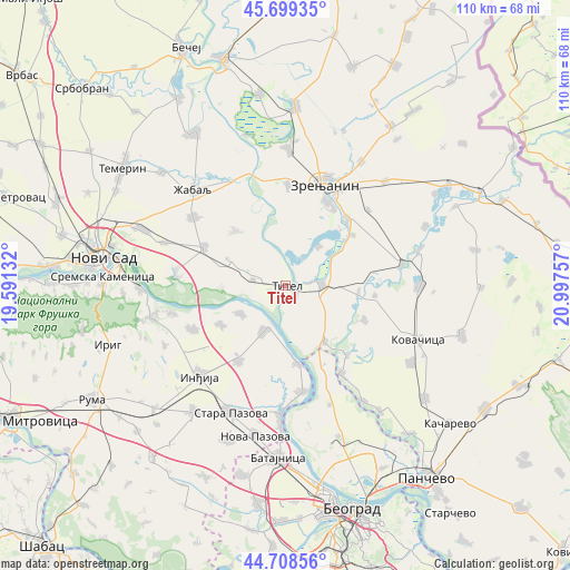
Titel GPS coordinates[2]
45° 12' 21.996" North, 20° 17' 39.984" East
| Map corner | latitude | longitude |
|---|---|---|
| Upper-left | 45.69935°, | 19.59132° |
| Center: | 45.20611°, | 20.29444° |
| Lower-right: | 44.70856°, | 20.99757° |
| Map W x H: | 110.2×110.2 km | = 68.5×68.5mi |
| max Lat: | 46.1° ⇑29.9% North |
| Titel: | 45.20611° |
| min Lat: | ⇓70.1% South 42.25846° |
| min Long | Titel | max Long |
| 18.9276° | 20.29444° | 22.77556° |
| W 46.3%⇐ | ⇒53.7% E |
Elevation
Elevation of Titel is 90 m = 295 ft, and this is 86.4 m = 283 ft below average elevation for this country.
| Max E: |
1421 m = 4662 ft | 48.5% |
| Avg. | 176.4 m = 579 ft | |
| Titel | 90 m = 295 ft | |
Min E: |
49 m = 161 ft | 51.5% |
See also: Serbia elevation on elevation.city.
Geographical zone
Titel is located in North temperate zone (between Tropic of Cancer and the Arctic Circle). Distance of this North polar circle is 2374.7 km =1475.6 mi to North.| Distance of | km | miles | from Titel |
|---|---|---|---|
| North Pole | 4980.6 | 3094.8 | to North |
| Arctic Circle | 2374.7 | 1475.6 | to North |
| Tropic Cancer | 2420.5 | 1504 | to South |
| Equator | 5026.4 | 3123.3 | to South |


Nearby cities:
15 places around Titel: (largest is in red/bold)
• Belo Blato
9.7 km =6 mi,  40°
40°
• Farkaždin
14 km =8.7 mi,  96°
96°
• Gardinovci
12.4 km =7.7 mi,  268°
268°
• Knićanin
2.9 km =1.8 mi,  138°
138°
• Krčedin
14.7 km =9.1 mi,  239°
239°
• Lok
6.5 km =4 mi,  279°
279°
• Lukino Selo
14.9 km =9.3 mi, 43°
• Mošorin
14.5 km =9 mi,  317°
317°
• Novi Slankamen
10 km =6.2 mi,  205°
205°
• Perlez
6.9 km =4.3 mi,  88°
88°
• Stajićevo
16.2 km =10.1 mi,  52°
52°
• Stari Slankamen
7.6 km =4.7 mi,  202°
202°
• Surduk
15.2 km =9.4 mi,  170°
170°
• Vilovo
11.9 km =7.4 mi,  293°
293°
• Čenta
13.2 km =8.2 mi,  145°
145°
Sources, notices
• [Note1] Compared only with cities in Serbia existing in our database
• [Src1] Map data: © OpenStreetMap contributors (CC-BY-SA)
• [Src2] Other city data from geonames.org with taken over terms of usage.
• [Src3] Geographical zone / Annual Mean Temperature by Robert A. Rohde @ Wikipedia
