Surduk geodata
Surduk (Vojvodina) is a populated place; located in Serbia in Europe/Belgrade (GMT+2) time zone. With population of 1,332 people, there are 279 cities with bigger population in this country. Compared to other cities in Serbia, 61.7% of cities are located further ↓South; 50.8% of cities are located further →East and 99.5% of cities have higher elevation than Surduk. Note1


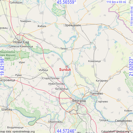
Surduk GPS coordinates[2]
45° 4' 16.248" North, 20° 19' 30.36" East
| Map corner | latitude | longitude |
|---|---|---|
| Upper-left | 45.56559°, | 19.62198° |
| Center: | 45.07118°, | 20.3251° |
| Lower-right: | 44.57246°, | 21.02823° |
| Map W x H: | 110.4×110.4 km | = 68.6×68.6mi |
| max Lat: | 46.1° ⇑38.3% North |
| Surduk: | 45.07118° |
| min Lat: | ⇓61.7% South 42.25846° |
| min Long | Surduk | max Long |
| 18.9276° | 20.3251° | 22.77556° |
| W 49.2%⇐ | ⇒50.8% E |
Elevation
Elevation of Surduk is 58 m = 190 ft, and this is 118.4 m = 388 ft below average elevation for this country.
| Max E: |
1421 m = 4662 ft | 99.5% |
| Avg. | 176.4 m = 579 ft | |
| Surduk | 58 m = 190 ft | |
Min E: |
49 m = 161 ft | 0.5% |
See also: Serbia elevation on elevation.city.
Geographical zone
Surduk is located in North temperate zone (between Tropic of Cancer and the Arctic Circle). Distance of this North polar circle is 2389.7 km =1484.9 mi to North.| Distance of | km | miles | from Surduk |
|---|---|---|---|
| North Pole | 4995.6 | 3104.1 | to North |
| Arctic Circle | 2389.7 | 1484.9 | to North |
| Tropic Cancer | 2405.5 | 1494.7 | to South |
| Equator | 5011.4 | 3113.9 | to South |


Nearby cities:
15 places around Surduk: (largest is in red/bold)
• Baranda
9.3 km =5.8 mi,  80°
80°
• Belegiš
5.8 km =3.6 mi,  173°
173°
• Knićanin
12.9 km =8 mi,  357°
357°
• Novi Banovci
13.2 km =8.2 mi,  195°
195°
• Novi Karlovci
11.4 km =7.1 mi,  272°
272°
• Novi Slankamen
9.1 km =5.7 mi,  311°
311°
• Opovo
8.5 km =5.3 mi,  104°
104°
• Perlez
15.9 km =9.9 mi,  16°
16°
• Sakule
15.2 km =9.4 mi,  56°
56°
• Sefkerin
14.4 km =8.9 mi,  120°
120°
• Stara Pazova
16.1 km =10 mi,  233°
233°
• Stari Banovci
10.2 km =6.3 mi, 198°
• Stari Slankamen
9.5 km =5.9 mi,  326°
326°
• Titel
15.2 km =9.4 mi,  350°
350°
• Čenta
6.5 km =4 mi,  50°
50°
Sources, notices
• [Note1] Compared only with cities in Serbia existing in our database
• [Src1] Map data: © OpenStreetMap contributors (CC-BY-SA)
• [Src2] Other city data from geonames.org with taken over terms of usage.
• [Src3] Geographical zone / Annual Mean Temperature by Robert A. Rohde @ Wikipedia
