Prokuplje geodata
Prokuplje (Central Serbia) is a seat of a second-order administrative division; located in Serbia in Europe/Belgrade (GMT+2) time zone. With population of 27,673 people, there are 30 cities with bigger population in this country. Compared to other cities in Serbia, 89.8% of cities are located further ↑North; 87.3% of cities are located further ←West and 82.1% of cities have lower elevation than Prokuplje. Note1


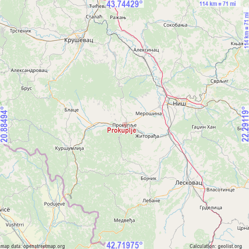
Prokuplje GPS coordinates[2]
43° 14' 3.012" North, 21° 35' 17.016" East
| Map corner | latitude | longitude |
|---|---|---|
| Upper-left | 43.74429°, | 20.88494° |
| Center: | 43.23417°, | 21.58806° |
| Lower-right: | 42.71975°, | 22.29119° |
| Map W x H: | 113.9×113.9 km | = 70.8×70.8mi |
| max Lat: | 46.1° ⇑89.8% North |
| Prokuplje: | 43.23417° |
| min Lat: | ⇓10.2% South 42.25846° |
| min Long | Prokuplje | max Long |
| 18.9276° | 21.58806° | 22.77556° |
| W 87.3%⇐ | ⇒12.7% E |
Elevation
Elevation of Prokuplje is 259 m = 850 ft, and this is 82.6 m = 271 ft above average elevation for this country.
| Max E: |
1421 m = 4662 ft | 17.9% |
| Prokuplje | 259 m 850 ft | |
| Avg. | 176.4 m = 579 ft | |
Min E: |
49 m = 161 ft | 82.1% |
See also: Serbia elevation on elevation.city.
Geographical zone
Prokuplje is located in North temperate zone (between Tropic of Cancer and the Arctic Circle). Distance of this Northern Tropic circle is 2201.3 km =1367.8 mi to South.| Distance of | km | miles | from Prokuplje |
|---|---|---|---|
| North Pole | 5199.9 | 3231.1 | to North |
| Arctic Circle | 2594 | 1611.8 | to North |
| Tropic Cancer | 2201.3 | 1367.8 | to South |
| Equator | 4807.2 | 2987.1 | to South |


Nearby cities:
15 places around Prokuplje: (largest is in red/bold)
• Aleksinac
35.5 km =22.1 mi,  15°
15°
• Bace
19.8 km =12.3 mi,  265°
265°
• Beloljin
15.5 km =9.6 mi, 271°
• Blace
25.4 km =15.8 mi,  285°
285°
• Bojnik
26.9 km =16.7 mi,  156°
156°
• Doljevac
20.2 km =12.6 mi,  101°
101°
• Donja Konjuša
14.1 km =8.8 mi,  264°
264°
• Kuršumlija
27.7 km =17.2 mi,  247°
247°
• Merošina
12 km =7.5 mi,  62°
62°
• Niš
27.4 km =17 mi,  68°
68°
• Niška Banja
34.5 km =21.4 mi,  78°
78°
• Suvi Do
20.9 km =13 mi,  277°
277°
• Tulare
16.9 km =10.5 mi, 267°
• Žitni Potok
16 km =9.9 mi,  183°
183°
• Žitorađa
11.3 km =7 mi,  115°
115°
Sources, notices
• [Note1] Compared only with cities in Serbia existing in our database
• [Src1] Map data: © OpenStreetMap contributors (CC-BY-SA)
• [Src2] Other city data from geonames.org with taken over terms of usage.
• [Src3] Geographical zone / Annual Mean Temperature by Robert A. Rohde @ Wikipedia
