Tulare geodata
Tulare (Central Serbia) is a populated place; located in Serbia in Europe/Belgrade (GMT+2) time zone. With population of 533 people, there are 355 cities with bigger population in this country. Compared to other cities in Serbia, 90% of cities are located further ↑North; 83.4% of cities are located further ←West and 86.4% of cities have lower elevation than Tulare. Note1


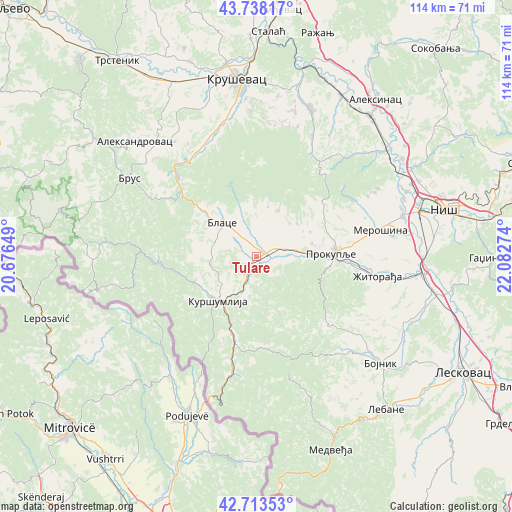
Tulare GPS coordinates[2]
43° 13' 40.8" North, 21° 22' 46.596" East
| Map corner | latitude | longitude |
|---|---|---|
| Upper-left | 43.73817°, | 20.67649° |
| Center: | 43.228°, | 21.37961° |
| Lower-right: | 42.71353°, | 22.08274° |
| Map W x H: | 113.9×113.9 km | = 70.8×70.8mi |
| max Lat: | 46.1° ⇑90% North |
| Tulare: | 43.228° |
| min Lat: | ⇓10% South 42.25846° |
| min Long | Tulare | max Long |
| 18.9276° | 21.37961° | 22.77556° |
| W 83.4%⇐ | ⇒16.6% E |
Elevation
Elevation of Tulare is 321 m = 1053 ft, and this is 144.6 m = 474 ft above average elevation for this country.
| Max E: |
1421 m = 4662 ft | 13.6% |
| Tulare | 321 m 1053 ft | |
| Avg. | 176.4 m = 579 ft | |
Min E: |
49 m = 161 ft | 86.4% |
See also: Serbia elevation on elevation.city.
Geographical zone
Tulare is located in North temperate zone (between Tropic of Cancer and the Arctic Circle). Distance of this Northern Tropic circle is 2200.6 km =1367.4 mi to South.| Distance of | km | miles | from Tulare |
|---|---|---|---|
| North Pole | 5200.6 | 3231.5 | to North |
| Arctic Circle | 2594.7 | 1612.3 | to North |
| Tropic Cancer | 2200.6 | 1367.4 | to South |
| Equator | 4806.5 | 2986.6 | to South |


Nearby cities:
15 places around Tulare: (largest is in red/bold)
• Aleksandrovac
36.8 km =22.9 mi,  314°
314°
• Bace
3 km =1.9 mi,  251°
251°
• Beloljin
1.8 km =1.1 mi,  50°
50°
• Blace
10.7 km =6.6 mi, 314°
• Bojnik
36.6 km =22.7 mi,  130°
130°
• Doljevac
36.9 km =22.9 mi,  95°
95°
• Donja Konjuša
2.9 km =1.8 mi, 101°
• Kruševac
39.3 km =24.4 mi,  354°
354°
• Kuršumlija
13.2 km =8.2 mi,  220°
220°
• Merošina
28.3 km =17.6 mi,  77°
77°
• Niš
43.7 km =27.2 mi, 75°
• Prokuplje
16.9 km =10.5 mi,  87°
87°
• Suvi Do
5.1 km =3.2 mi, 311°
• Žitni Potok
22 km =13.7 mi, 134°
• Žitorađa
27.4 km =17 mi, 98°
Sources, notices
• [Note1] Compared only with cities in Serbia existing in our database
• [Src1] Map data: © OpenStreetMap contributors (CC-BY-SA)
• [Src2] Other city data from geonames.org with taken over terms of usage.
• [Src3] Geographical zone / Annual Mean Temperature by Robert A. Rohde @ Wikipedia
