Niška Banja geodata
Niška Banja (Central Serbia) is a seat of a third-order administrative division; located in Serbia in Europe/Belgrade (GMT+2) time zone. In our database, there are 365 cities with bigger population. Compared to other cities in Serbia, 88.4% of cities are located further ↑North; 95.2% of cities are located further ←West and 79.8% of cities have lower elevation than Niška Banja. Note1


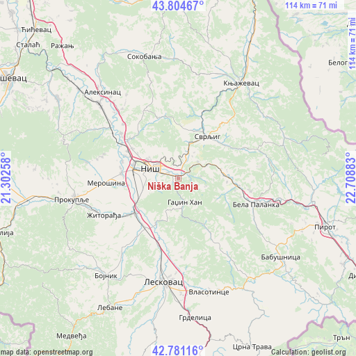
Niška Banja GPS coordinates[2]
43° 17' 42.252" North, 22° 0' 20.52" East
| Map corner | latitude | longitude |
|---|---|---|
| Upper-left | 43.80467°, | 21.30258° |
| Center: | 43.29507°, | 22.0057° |
| Lower-right: | 42.78116°, | 22.70883° |
| Map W x H: | 113.8×113.8 km | = 70.7×70.7mi |
| max Lat: | 46.1° ⇑88.4% North |
| Niška Banja: | 43.29507° |
| min Lat: | ⇓11.6% South 42.25846° |
| min Long | Niška Banja | max Long |
| 18.9276° | 22.0057° | 22.77556° |
| W 95.2%⇐ | ⇒4.8% E |
Elevation
Elevation of Niška Banja is 234 m = 768 ft, and this is 57.6 m = 189 ft above average elevation for this country.
| Max E: |
1421 m = 4662 ft | 20.2% |
| Niška Banja | 234 m 768 ft | |
| Avg. | 176.4 m = 579 ft | |
Min E: |
49 m = 161 ft | 79.8% |
See also: Serbia elevation on elevation.city.
Geographical zone
Niška Banja is located in North temperate zone (between Tropic of Cancer and the Arctic Circle). Distance of this Northern Tropic circle is 2208 km =1372 mi to South.| Distance of | km | miles | from Niška Banja |
|---|---|---|---|
| North Pole | 5193.1 | 3226.8 | to North |
| Arctic Circle | 2587.2 | 1607.6 | to North |
| Tropic Cancer | 2208 | 1372 | to South |
| Equator | 4814 | 2991.3 | to South |


Nearby cities:
15 places around Niška Banja: (largest is in red/bold)
• Aleksinac
36.5 km =22.7 mi,  318°
318°
• Bela Palanka
26.2 km =16.3 mi,  109°
109°
• Bojnik
39 km =24.2 mi,  216°
216°
• Dolac naselje
16.2 km =10.1 mi,  89°
89°
• Doljevac
17.7 km =11 mi,  232°
232°
• Gadžin Han
8.3 km =5.2 mi,  165°
165°
• Knjazevac
36.4 km =22.6 mi,  33°
33°
• Leskovac
33.4 km =20.8 mi,  188°
188°
• Merošina
23.1 km =14.4 mi,  266°
266°
• Niš
8.9 km =5.5 mi,  291°
291°
• Prokuplje
34.5 km =21.4 mi,  258°
258°
• Soko Banja
40.2 km =25 mi,  344°
344°
• Svrljig
16.1 km =10 mi,  35°
35°
• Vlasotince
37.9 km =23.5 mi,  164°
164°
• Žitorađa
26.4 km =16.4 mi,  243°
243°
Sources, notices
• [Note1] Compared only with cities in Serbia existing in our database
• [Src1] Map data: © OpenStreetMap contributors (CC-BY-SA)
• [Src2] Other city data from geonames.org with taken over terms of usage.
• [Src3] Geographical zone / Annual Mean Temperature by Robert A. Rohde @ Wikipedia
