Ovča geodata
Ovča (Central Serbia) is a populated place; located in Serbia in Europe/Belgrade (GMT+2) time zone. With population of 2,567 people, there are 173 cities with bigger population in this country. Compared to other cities in Serbia, 52.4% of cities are located further ↓South; 60.3% of cities are located further ←West and 98.6% of cities have higher elevation than Ovča. Note1


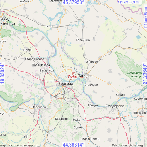
Ovča GPS coordinates[2]
44° 53' 0.564" North, 20° 32' 0.096" East
| Map corner | latitude | longitude |
|---|---|---|
| Upper-left | 45.37953°, | 19.83024° |
| Center: | 44.88349°, | 20.53336° |
| Lower-right: | 44.38314°, | 21.23649° |
| Map W x H: | 110.8×110.8 km | = 68.8×68.8mi |
| max Lat: | 46.1° ⇑47.6% North |
| Ovča: | 44.88349° |
| min Lat: | ⇓52.4% South 42.25846° |
| min Long | Ovča | max Long |
| 18.9276° | 20.53336° | 22.77556° |
| W 60.3%⇐ | ⇒39.7% E |
Elevation
Elevation of Ovča is 71 m = 233 ft, and this is 105.4 m = 346 ft below average elevation for this country.
| Max E: |
1421 m = 4662 ft | 98.6% |
| Avg. | 176.4 m = 579 ft | |
| Ovča | 71 m = 233 ft | |
Min E: |
49 m = 161 ft | 1.4% |
See also: Serbia elevation on elevation.city.
Geographical zone
Ovča is located in North temperate zone (between Tropic of Cancer and the Arctic Circle). Distance of this Northern Tropic circle is 2384.7 km =1481.8 mi to South.| Distance of | km | miles | from Ovča |
|---|---|---|---|
| North Pole | 5016.5 | 3117.1 | to North |
| Arctic Circle | 2410.6 | 1497.9 | to North |
| Tropic Cancer | 2384.7 | 1481.8 | to South |
| Equator | 4990.6 | 3101 | to South |


Nearby cities:
15 places around Ovča: (largest is in red/bold)
• Belgrade
10.3 km =6.4 mi,  211°
211°
• Crepaja
16.2 km =10.1 mi,  30°
30°
• Novi Beograd
12.2 km =7.6 mi,  224°
224°
• Opovo
20.4 km =12.7 mi,  336°
336°
• Palilula
8.1 km =5 mi,  189°
189°
• Pančevo
8.6 km =5.3 mi,  98°
98°
• Rakovica
17.3 km =10.7 mi,  204°
204°
• Savski Venac
13.2 km =8.2 mi, 208°
• Sefkerin
14.1 km =8.8 mi, 343°
• Stari Grad
9.2 km =5.7 mi, 217°
• Voždovac
12.5 km =7.8 mi, 201°
• Vračar
11.1 km =6.9 mi, 204°
• Zemun
11.2 km =7 mi,  248°
248°
• Zvezdara
12.1 km =7.5 mi,  180°
180°
• Čukarica
14.3 km =8.9 mi, 218°
Sources, notices
• [Note1] Compared only with cities in Serbia existing in our database
• [Src1] Map data: © OpenStreetMap contributors (CC-BY-SA)
• [Src2] Other city data from geonames.org with taken over terms of usage.
• [Src3] Geographical zone / Annual Mean Temperature by Robert A. Rohde @ Wikipedia
