Opovo geodata
Opovo (Vojvodina) is a seat of a third-order administrative division; located in Serbia in Europe/Belgrade (GMT+2) time zone. With population of 4,769 people, there are 97 cities with bigger population in this country. Compared to other cities in Serbia, 60.5% of cities are located further ↓South; 53.7% of cities are located further ←West and 97.5% of cities have higher elevation than Opovo. Note1


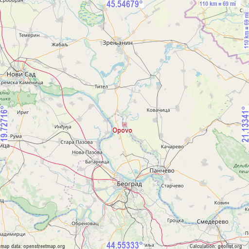
Opovo GPS coordinates[2]
45° 3' 7.992" North, 20° 25' 49.008" East
| Map corner | latitude | longitude |
|---|---|---|
| Upper-left | 45.54679°, | 19.72716° |
| Center: | 45.05222°, | 20.43028° |
| Lower-right: | 44.55333°, | 21.13341° |
| Map W x H: | 110.5×110.5 km | = 68.7×68.7mi |
| max Lat: | 46.1° ⇑39.5% North |
| Opovo: | 45.05222° |
| min Lat: | ⇓60.5% South 42.25846° |
| min Long | Opovo | max Long |
| 18.9276° | 20.43028° | 22.77556° |
| W 53.7%⇐ | ⇒46.3% E |
Elevation
Elevation of Opovo is 73 m = 240 ft, and this is 103.4 m = 339 ft below average elevation for this country.
| Max E: |
1421 m = 4662 ft | 97.5% |
| Avg. | 176.4 m = 579 ft | |
| Opovo | 73 m = 240 ft | |
Min E: |
49 m = 161 ft | 2.5% |
See also: Serbia elevation on elevation.city.
Geographical zone
Opovo is located in North temperate zone (between Tropic of Cancer and the Arctic Circle). Distance of this North polar circle is 2391.8 km =1486.2 mi to North.| Distance of | km | miles | from Opovo |
|---|---|---|---|
| North Pole | 4997.7 | 3105.4 | to North |
| Arctic Circle | 2391.8 | 1486.2 | to North |
| Tropic Cancer | 2403.4 | 1493.4 | to South |
| Equator | 5009.3 | 3112.6 | to South |


Nearby cities:
15 places around Opovo: (largest is in red/bold)
• Baranda
3.7 km =2.3 mi,  15°
15°
• Belegiš
8.5 km =5.3 mi,  244°
244°
• Crepaja
16.9 km =10.5 mi,  106°
106°
• Debeljača
13.6 km =8.5 mi,  81°
81°
• Farkaždin
15.9 km =9.9 mi,  12°
12°
• Idvor
16.6 km =10.3 mi, 23°
• Kovačica
16.4 km =10.2 mi,  66°
66°
• Novi Banovci
15.8 km =9.8 mi,  227°
227°
• Novi Slankamen
17.1 km =10.6 mi,  298°
298°
• Sakule
11.4 km =7.1 mi, 22°
• Sefkerin
6.7 km =4.2 mi,  141°
141°
• Stari Banovci
13.8 km =8.6 mi, 236°
• Stari Slankamen
16.9 km =10.5 mi,  306°
306°
• Surduk
8.5 km =5.3 mi,  284°
284°
• Čenta
7 km =4.3 mi,  332°
332°
Sources, notices
• [Note1] Compared only with cities in Serbia existing in our database
• [Src1] Map data: © OpenStreetMap contributors (CC-BY-SA)
• [Src2] Other city data from geonames.org with taken over terms of usage.
• [Src3] Geographical zone / Annual Mean Temperature by Robert A. Rohde @ Wikipedia
