Sefkerin geodata
Sefkerin (Vojvodina) is a populated place; located in Serbia in Europe/Belgrade (GMT+2) time zone. With population of 2,836 people, there are 158 cities with bigger population in this country. Compared to other cities in Serbia, 57.8% of cities are located further ↓South; 58% of cities are located further ←West and 98% of cities have higher elevation than Sefkerin. Note1


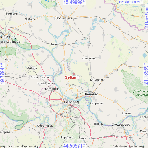
Sefkerin GPS coordinates[2]
45° 0' 18.036" North, 20° 28' 57.216" East
| Map corner | latitude | longitude |
|---|---|---|
| Upper-left | 45.49999°, | 19.77944° |
| Center: | 45.00501°, | 20.48256° |
| Lower-right: | 44.50571°, | 21.18569° |
| Map W x H: | 110.6×110.6 km | = 68.7×68.7mi |
| max Lat: | 46.1° ⇑42.2% North |
| Sefkerin: | 45.00501° |
| min Lat: | ⇓57.8% South 42.25846° |
| min Long | Sefkerin | max Long |
| 18.9276° | 20.48256° | 22.77556° |
| W 58%⇐ | ⇒42% E |
Elevation
Elevation of Sefkerin is 72 m = 236 ft, and this is 104.4 m = 343 ft below average elevation for this country.
| Max E: |
1421 m = 4662 ft | 98% |
| Avg. | 176.4 m = 579 ft | |
| Sefkerin | 72 m = 236 ft | |
Min E: |
49 m = 161 ft | 2% |
See also: Serbia elevation on elevation.city.
Geographical zone
Sefkerin is located in North temperate zone (between Tropic of Cancer and the Arctic Circle). Distance of this North polar circle is 2397.1 km =1489.5 mi to North.| Distance of | km | miles | from Sefkerin |
|---|---|---|---|
| North Pole | 5003 | 3108.7 | to North |
| Arctic Circle | 2397.1 | 1489.5 | to North |
| Tropic Cancer | 2398.2 | 1490.2 | to South |
| Equator | 5004.1 | 3109.4 | to South |


Nearby cities:
15 places around Sefkerin: (largest is in red/bold)
• Baranda
9.4 km =5.8 mi,  340°
340°
• Belegiš
11.8 km =7.3 mi,  277°
277°
• Crepaja
12.2 km =7.6 mi,  87°
87°
• Debeljača
11.9 km =7.4 mi,  51°
51°
• Idvor
20.6 km =12.8 mi,  6°
6°
• Kovačica
16.1 km =10 mi,  42°
42°
• Novi Banovci
16.7 km =10.4 mi,  251°
251°
• Opovo
6.7 km =4.2 mi,  321°
321°
• Ovča
14.1 km =8.8 mi,  163°
163°
• Pančevo
19.4 km =12.1 mi,  139°
139°
• Sakule
15.8 km =9.8 mi,  1°
1°
• Stari Banovci
15.8 km =9.8 mi,  261°
261°
• Surduk
14.4 km =8.9 mi,  300°
300°
• Zemun
18.8 km =11.7 mi,  199°
199°
• Čenta
13.6 km =8.5 mi,  327°
327°
Sources, notices
• [Note1] Compared only with cities in Serbia existing in our database
• [Src1] Map data: © OpenStreetMap contributors (CC-BY-SA)
• [Src2] Other city data from geonames.org with taken over terms of usage.
• [Src3] Geographical zone / Annual Mean Temperature by Robert A. Rohde @ Wikipedia
