Obrenovac geodata
Obrenovac (Central Serbia) is a seat of a third-order administrative division; located in Serbia in Europe/Belgrade (GMT+2) time zone. With population of 16,821 people, there are 44 cities with bigger population in this country. Compared to other cities in Serbia, 61.9% of cities are located further ↑North; 58.3% of cities are located further →East and 78.9% of cities have higher elevation than Obrenovac. Note1
Administrative division(s):
- Level 1: Central Serbia
- Level 2: Belgrade
- Level 3: Opština Beograd-Obrenovac


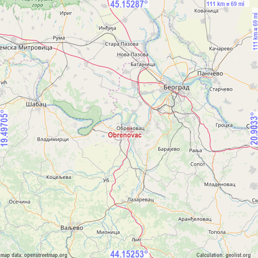
Obrenovac GPS coordinates[2]
44° 39' 17.496" North, 20° 12' 0.612" East
| Map corner | latitude | longitude |
|---|---|---|
| Upper-left | 45.15287°, | 19.49705° |
| Center: | 44.65486°, | 20.20017° |
| Lower-right: | 44.15253°, | 20.9033° |
| Map W x H: | 111.2×111.2 km | = 69.1×69.1mi |
| max Lat: | 46.1° ⇑61.9% North |
| Obrenovac: | 44.65486° |
| min Lat: | ⇓38.1% South 42.25846° |
| min Long | Obrenovac | max Long |
| 18.9276° | 20.20017° | 22.77556° |
| W 41.7%⇐ | ⇒58.3% E |
Elevation
Elevation of Obrenovac is 78 m = 256 ft, and this is 98.4 m = 323 ft below average elevation for this country.
| Max E: |
1421 m = 4662 ft | 78.9% |
| Avg. | 176.4 m = 579 ft | |
| Obrenovac | 78 m = 256 ft | |
Min E: |
49 m = 161 ft | 21.1% |
See also: Serbia elevation on elevation.city.
Geographical zone
Obrenovac is located in North temperate zone (between Tropic of Cancer and the Arctic Circle). Distance of this Northern Tropic circle is 2359.2 km =1465.9 mi to South.| Distance of | km | miles | from Obrenovac |
|---|---|---|---|
| North Pole | 5041.9 | 3132.9 | to North |
| Arctic Circle | 2436 | 1513.7 | to North |
| Tropic Cancer | 2359.2 | 1465.9 | to South |
| Equator | 4965.2 | 3085.2 | to South |


Nearby cities:
15 places around Obrenovac: (largest is in red/bold)
• Barič
4.7 km =2.9 mi,  95°
95°
• Bečmen
13.9 km =8.6 mi,  1°
1°
• Boljevci
7.9 km =4.9 mi,  13°
13°
• Grabovac
10.9 km =6.8 mi,  236°
236°
• Kupinovo
13.2 km =8.2 mi,  295°
295°
• Mala Moštanica
8.6 km =5.3 mi, 102°
• Ostružnica
12.4 km =7.7 mi,  49°
49°
• Sremčica
15.4 km =9.6 mi,  80°
80°
• Stepojevac
17.5 km =10.9 mi,  154°
154°
• Stubline
10.3 km =6.4 mi,  210°
210°
• Surčin
16.6 km =10.3 mi,  22°
22°
• Umka
8.7 km =5.4 mi,  72°
72°
• Velika Moštanica
12.2 km =7.6 mi, 84°
• Vranić
11.7 km =7.3 mi,  119°
119°
• Zvečka
3.3 km =2.1 mi, 240°
Sources, notices
• [Note1] Compared only with cities in Serbia existing in our database
• [Src1] Map data: © OpenStreetMap contributors (CC-BY-SA)
• [Src2] Other city data from geonames.org with taken over terms of usage.
• [Src3] Geographical zone / Annual Mean Temperature by Robert A. Rohde @ Wikipedia
