Surčin geodata
Surčin (Central Serbia) is a seat of a third-order administrative division; located in Serbia in Europe/Belgrade (GMT+2) time zone. With population of 12,575 people, there are 50 cities with bigger population in this country. Compared to other cities in Serbia, 53.5% of cities are located further ↑North; 54.6% of cities are located further →East and 53.1% of cities have higher elevation than Surčin. Note1
Administrative division(s):
- Level 1: Central Serbia
- Level 2: Belgrade
- Level 3: Opština Beograd-Surčin


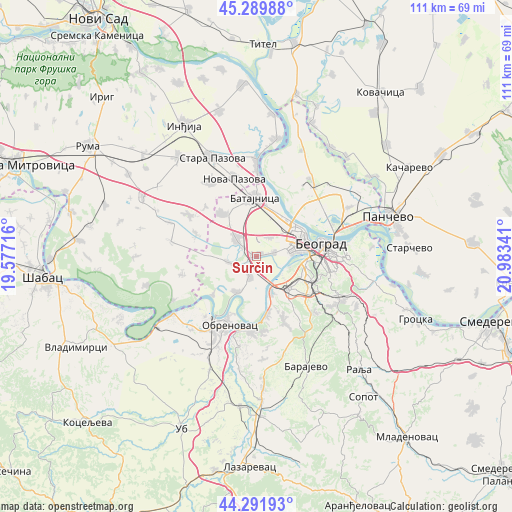
Surčin GPS coordinates[2]
44° 47' 35.016" North, 20° 16' 49.008" East
| Map corner | latitude | longitude |
|---|---|---|
| Upper-left | 45.28988°, | 19.57716° |
| Center: | 44.79306°, | 20.28028° |
| Lower-right: | 44.29193°, | 20.98341° |
| Map W x H: | 111×111 km | = 69×69mi |
| max Lat: | 46.1° ⇑53.5% North |
| Surčin: | 44.79306° |
| min Lat: | ⇓46.5% South 42.25846° |
| min Long | Surčin | max Long |
| 18.9276° | 20.28028° | 22.77556° |
| W 45.4%⇐ | ⇒54.6% E |
Elevation
Elevation of Surčin is 87 m = 285 ft, and this is 89.4 m = 293 ft below average elevation for this country.
| Max E: |
1421 m = 4662 ft | 53.1% |
| Avg. | 176.4 m = 579 ft | |
| Surčin | 87 m = 285 ft | |
Min E: |
49 m = 161 ft | 46.9% |
See also: Serbia elevation on elevation.city.
Geographical zone
Surčin is located in North temperate zone (between Tropic of Cancer and the Arctic Circle). Distance of this Northern Tropic circle is 2374.6 km =1475.5 mi to South.| Distance of | km | miles | from Surčin |
|---|---|---|---|
| North Pole | 5026.5 | 3123.3 | to North |
| Arctic Circle | 2420.7 | 1504.2 | to North |
| Tropic Cancer | 2374.6 | 1475.5 | to South |
| Equator | 4980.5 | 3094.7 | to South |


Nearby cities:
15 places around Surčin: (largest is in red/bold)
• Belgrade
14.6 km =9.1 mi,  85°
85°
• Bečmen
6.1 km =3.8 mi,  255°
255°
• Boljevci
8.9 km =5.5 mi,  210°
210°
• Dobanovci
5.7 km =3.5 mi,  310°
310°
• Novi Beograd
11.4 km =7.1 mi,  83°
83°
• Ostružnica
7.9 km =4.9 mi,  157°
157°
• Rakovica
13.9 km =8.6 mi,  114°
114°
• Savski Venac
13.8 km =8.6 mi,  96°
96°
• Stari Grad
14.6 km =9.1 mi, 79°
• Ugrinovci
11.8 km =7.3 mi,  321°
321°
• Umka
12.9 km =8 mi,  171°
171°
• Velika Moštanica
15.4 km =9.6 mi, 157°
• Vračar
15.4 km =9.6 mi, 90°
• Zemun
11.2 km =7 mi,  58°
58°
• Čukarica
11.1 km =6.9 mi, 96°
Sources, notices
• [Note1] Compared only with cities in Serbia existing in our database
• [Src1] Map data: © OpenStreetMap contributors (CC-BY-SA)
• [Src2] Other city data from geonames.org with taken over terms of usage.
• [Src3] Geographical zone / Annual Mean Temperature by Robert A. Rohde @ Wikipedia
