Stepojevac geodata
Stepojevac (Central Serbia) is a populated place; located in Serbia in Europe/Belgrade (GMT+2) time zone. With population of 2,773 people, there are 160 cities with bigger population in this country. Compared to other cities in Serbia, 70.5% of cities are located further ↑North; 53.5% of cities are located further →East and 66.7% of cities have lower elevation than Stepojevac. Note1
Administrative division(s):
- Level 1: Central Serbia
- Level 2: Belgrade
- Level 3: Opština Beograd-Lazarevac


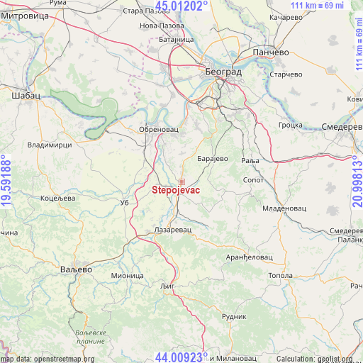
Stepojevac GPS coordinates[2]
44° 30' 46.008" North, 20° 17' 42" East
| Map corner | latitude | longitude |
|---|---|---|
| Upper-left | 45.01202°, | 19.59188° |
| Center: | 44.51278°, | 20.295° |
| Lower-right: | 44.00923°, | 20.99813° |
| Map W x H: | 111.5×111.5 km | = 69.3×69.3mi |
| max Lat: | 46.1° ⇑70.5% North |
| Stepojevac: | 44.51278° |
| min Lat: | ⇓29.5% South 42.25846° |
| min Long | Stepojevac | max Long |
| 18.9276° | 20.295° | 22.77556° |
| W 46.5%⇐ | ⇒53.5% E |
Elevation
Elevation of Stepojevac is 132 m = 433 ft, and this is 44.4 m = 146 ft below average elevation for this country.
| Max E: |
1421 m = 4662 ft | 33.3% |
| Avg. | 176.4 m = 579 ft | |
| Stepojevac | 132 m = 433 ft | |
Min E: |
49 m = 161 ft | 66.7% |
See also: Serbia elevation on elevation.city.
Geographical zone
Stepojevac is located in North temperate zone (between Tropic of Cancer and the Arctic Circle). Distance of this Northern Tropic circle is 2343.4 km =1456.1 mi to South.| Distance of | km | miles | from Stepojevac |
|---|---|---|---|
| North Pole | 5057.7 | 3142.7 | to North |
| Arctic Circle | 2451.8 | 1523.5 | to North |
| Tropic Cancer | 2343.4 | 1456.1 | to South |
| Equator | 4949.4 | 3075.4 | to South |


Nearby cities:
15 places around Stepojevac: (largest is in red/bold)
• Barajevo
12.1 km =7.5 mi,  52°
52°
• Barič
15.6 km =9.7 mi,  349°
349°
• Grabovac
19.3 km =12 mi,  300°
300°
• Lajkovac
19 km =11.8 mi,  212°
212°
• Lazarevac
14.5 km =9 mi,  192°
192°
• Mala Moštanica
14 km =8.7 mi,  3°
3°
• Obrenovac
17.5 km =10.9 mi,  334°
334°
• Sopot
22.1 km =13.7 mi,  87°
87°
• Sremčica
19.8 km =12.3 mi,  22°
22°
• Stubline
14.4 km =8.9 mi, 298°
• Ub
18.6 km =11.6 mi,  250°
250°
• Umka
18.4 km =11.4 mi, 2°
• Velika Moštanica
17.5 km =10.9 mi, 15°
• Vranić
10.3 km =6.4 mi, 15°
• Zvečka
17.6 km =10.9 mi,  323°
323°
Sources, notices
• [Note1] Compared only with cities in Serbia existing in our database
• [Src1] Map data: © OpenStreetMap contributors (CC-BY-SA)
• [Src2] Other city data from geonames.org with taken over terms of usage.
• [Src3] Geographical zone / Annual Mean Temperature by Robert A. Rohde @ Wikipedia
