Boljevci geodata
Boljevci (Central Serbia) is a populated place; located in Serbia in Europe/Belgrade (GMT+2) time zone. With population of 3,990 people, there are 113 cities with bigger population in this country. Compared to other cities in Serbia, 57.6% of cities are located further ↑North; 57.1% of cities are located further →East and 94.6% of cities have higher elevation than Boljevci. Note1


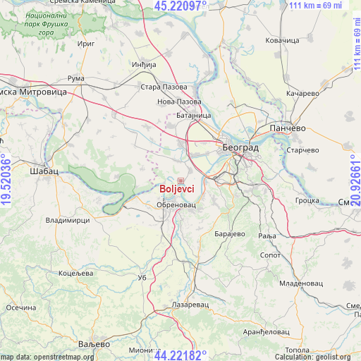
Boljevci GPS coordinates[2]
44° 43' 24.78" North, 20° 13' 24.528" East
| Map corner | latitude | longitude |
|---|---|---|
| Upper-left | 45.22097°, | 19.52036° |
| Center: | 44.72355°, | 20.22348° |
| Lower-right: | 44.22182°, | 20.92661° |
| Map W x H: | 111.1×111.1 km | = 69×69mi |
| max Lat: | 46.1° ⇑57.6% North |
| Boljevci: | 44.72355° |
| min Lat: | ⇓42.4% South 42.25846° |
| min Long | Boljevci | max Long |
| 18.9276° | 20.22348° | 22.77556° |
| W 42.9%⇐ | ⇒57.1% E |
Elevation
Elevation of Boljevci is 75 m = 246 ft, and this is 101.4 m = 333 ft below average elevation for this country.
| Max E: |
1421 m = 4662 ft | 94.6% |
| Avg. | 176.4 m = 579 ft | |
| Boljevci | 75 m = 246 ft | |
Min E: |
49 m = 161 ft | 5.4% |
See also: Serbia elevation on elevation.city.
Geographical zone
Boljevci is located in North temperate zone (between Tropic of Cancer and the Arctic Circle). Distance of this Northern Tropic circle is 2366.9 km =1470.7 mi to South.| Distance of | km | miles | from Boljevci |
|---|---|---|---|
| North Pole | 5034.3 | 3128.2 | to North |
| Arctic Circle | 2428.4 | 1508.9 | to North |
| Tropic Cancer | 2366.9 | 1470.7 | to South |
| Equator | 4972.8 | 3090 | to South |


Nearby cities:
15 places around Boljevci: (largest is in red/bold)
• Barič
8.6 km =5.3 mi,  160°
160°
• Bečmen
6.4 km =4 mi,  347°
347°
• Dobanovci
11.4 km =7.1 mi,  0°
0°
• Kupinovo
13.9 km =8.6 mi,  262°
262°
• Mala Moštanica
11.5 km =7.1 mi,  145°
145°
• Obrenovac
7.9 km =4.9 mi,  193°
193°
• Ostružnica
7.5 km =4.7 mi,  86°
86°
• Sremčica
14.3 km =8.9 mi,  111°
111°
• Surčin
8.9 km =5.5 mi,  30°
30°
• Ugrinovci
17.2 km =10.7 mi, 350°
• Umka
8.2 km =5.1 mi,  128°
128°
• Velika Moštanica
12.2 km =7.6 mi,  122°
122°
• Vranić
15.8 km =9.8 mi, 148°
• Zvečka
10.4 km =6.5 mi,  206°
206°
• Čukarica
16.9 km =10.5 mi,  67°
67°
Sources, notices
• [Note1] Compared only with cities in Serbia existing in our database
• [Src1] Map data: © OpenStreetMap contributors (CC-BY-SA)
• [Src2] Other city data from geonames.org with taken over terms of usage.
• [Src3] Geographical zone / Annual Mean Temperature by Robert A. Rohde @ Wikipedia
