Leskovac geodata
Leskovac (Central Serbia) is a seat of a second-order administrative division; located in Serbia in Europe/Belgrade (GMT+2) time zone. With population of 94,758 people, there are 7 cities with bigger population in this country. Compared to other cities in Serbia, 93.7% of cities are located further ↑North; 94.6% of cities are located further ←West and 79.1% of cities have lower elevation than Leskovac. Note1


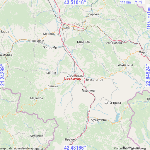
Leskovac GPS coordinates[2]
42° 59' 53.016" North, 21° 56' 45.996" East
| Map corner | latitude | longitude |
|---|---|---|
| Upper-left | 43.51016°, | 21.24299° |
| Center: | 42.99806°, | 21.94611° |
| Lower-right: | 42.48166°, | 22.64924° |
| Map W x H: | 114.4×114.4 km | = 71.1×71.1mi |
| max Lat: | 46.1° ⇑93.7% North |
| Leskovac: | 42.99806° |
| min Lat: | ⇓6.3% South 42.25846° |
| min Long | Leskovac | max Long |
| 18.9276° | 21.94611° | 22.77556° |
| W 94.6%⇐ | ⇒5.4% E |
Elevation
Elevation of Leskovac is 230 m = 755 ft, and this is 53.6 m = 176 ft above average elevation for this country.
| Max E: |
1421 m = 4662 ft | 20.9% |
| Leskovac | 230 m 755 ft | |
| Avg. | 176.4 m = 579 ft | |
Min E: |
49 m = 161 ft | 79.1% |
See also: Leskovac elevation on elevation.city.
Geographical zone
Leskovac is located in North temperate zone (between Tropic of Cancer and the Arctic Circle). Distance of this Northern Tropic circle is 2175 km =1351.5 mi to South.| Distance of | km | miles | from Leskovac |
|---|---|---|---|
| North Pole | 5226.1 | 3247.3 | to North |
| Arctic Circle | 2620.2 | 1628.1 | to North |
| Tropic Cancer | 2175 | 1351.5 | to South |
| Equator | 4780.9 | 2970.7 | to South |


Nearby cities:
15 places around Leskovac: (largest is in red/bold)
• Bela Palanka
38.4 km =23.9 mi,  50°
50°
• Bojnik
18.4 km =11.4 mi,  274°
274°
• Brezovica
19.6 km =12.2 mi,  105°
105°
• Crna Trava
35.5 km =22.1 mi,  126°
126°
• Doljevac
24.1 km =15 mi,  337°
337°
• Gadžin Han
25.9 km =16.1 mi,  15°
15°
• Lebane
18.9 km =11.7 mi,  244°
244°
• Medveđa
34.2 km =21.3 mi, 239°
• Merošina
36.6 km =22.7 mi,  330°
330°
• Niš
36.5 km =22.7 mi,  354°
354°
• Niška Banja
33.4 km =20.8 mi,  8°
8°
• Vladičin Han
33.7 km =20.9 mi,  163°
163°
• Vlasotince
15.7 km =9.8 mi,  102°
102°
• Žitni Potok
31.9 km =19.8 mi,  288°
288°
• Žitorađa
28.5 km =17.7 mi,  318°
318°
Sources, notices
• [Note1] Compared only with cities in Serbia existing in our database
• [Src1] Map data: © OpenStreetMap contributors (CC-BY-SA)
• [Src2] Other city data from geonames.org with taken over terms of usage.
• [Src3] Geographical zone / Annual Mean Temperature by Robert A. Rohde @ Wikipedia
