Vlasotince geodata
Vlasotince (Central Serbia) is a seat of a third-order administrative division; located in Serbia in Europe/Belgrade (GMT+2) time zone. In our database, there are 365 cities with bigger population. Compared to other cities in Serbia, 94.1% of cities are located further ↑North; 96.6% of cities are located further ←West and 82.5% of cities have lower elevation than Vlasotince. Note1


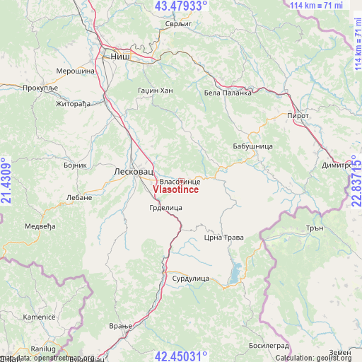
Vlasotince GPS coordinates[2]
42° 58' 1.092" North, 22° 8' 2.472" East
| Map corner | latitude | longitude |
|---|---|---|
| Upper-left | 43.47933°, | 21.4309° |
| Center: | 42.96697°, | 22.13402° |
| Lower-right: | 42.45031°, | 22.83715° |
| Map W x H: | 114.4×114.4 km | = 71.1×71.1mi |
| max Lat: | 46.1° ⇑94.1% North |
| Vlasotince: | 42.96697° |
| min Lat: | ⇓5.9% South 42.25846° |
| min Long | Vlasotince | max Long |
| 18.9276° | 22.13402° | 22.77556° |
| W 96.6%⇐ | ⇒3.4% E |
Elevation
Elevation of Vlasotince is 262 m = 860 ft, and this is 85.6 m = 281 ft above average elevation for this country.
| Max E: |
1421 m = 4662 ft | 17.5% |
| Vlasotince | 262 m 860 ft | |
| Avg. | 176.4 m = 579 ft | |
Min E: |
49 m = 161 ft | 82.5% |
See also: Serbia elevation on elevation.city.
Geographical zone
Vlasotince is located in North temperate zone (between Tropic of Cancer and the Arctic Circle). Distance of this Northern Tropic circle is 2171.6 km =1349.4 mi to South.| Distance of | km | miles | from Vlasotince |
|---|---|---|---|
| North Pole | 5229.6 | 3249.5 | to North |
| Arctic Circle | 2623.7 | 1630.3 | to North |
| Tropic Cancer | 2171.6 | 1349.4 | to South |
| Equator | 4777.5 | 2968.6 | to South |


Nearby cities:
15 places around Vlasotince: (largest is in red/bold)
• Bela Palanka
31.4 km =19.5 mi,  27°
27°
• Bojnik
34 km =21.1 mi,  278°
278°
• Brezovica
4 km =2.5 mi,  114°
114°
• Crna Trava
22 km =13.7 mi,  142°
142°
• Dolac naselje
37 km =23 mi,  9°
9°
• Doljevac
35.5 km =22.1 mi,  316°
316°
• Gadžin Han
29.6 km =18.4 mi,  343°
343°
• Lebane
32.6 km =20.3 mi,  261°
261°
• Leskovac
15.7 km =9.8 mi, 282°
• Niš
44 km =27.3 mi,  334°
334°
• Niška Banja
37.9 km =23.5 mi, 344°
• Pirot
42.2 km =26.2 mi,  60°
60°
• Surdulica
30.9 km =19.2 mi,  174°
174°
• Vladičin Han
29.4 km =18.3 mi,  191°
191°
• Žitorađa
42.2 km =26.2 mi,  305°
305°
Sources, notices
• [Note1] Compared only with cities in Serbia existing in our database
• [Src1] Map data: © OpenStreetMap contributors (CC-BY-SA)
• [Src2] Other city data from geonames.org with taken over terms of usage.
• [Src3] Geographical zone / Annual Mean Temperature by Robert A. Rohde @ Wikipedia
