Lebane geodata
Lebane (Central Serbia) is a seat of a third-order administrative division; located in Serbia in Europe/Belgrade (GMT+2) time zone. In our database, there are 365 cities with bigger population. Compared to other cities in Serbia, 94.6% of cities are located further ↑North; 90.9% of cities are located further ←West and 84.4% of cities have lower elevation than Lebane. Note1


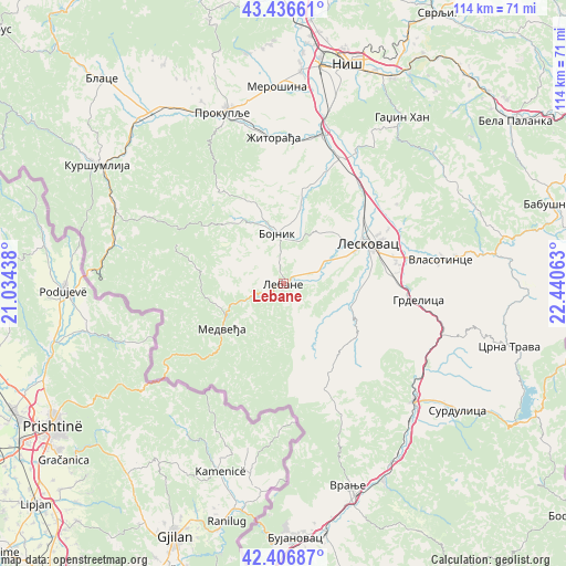
Lebane GPS coordinates[2]
42° 55' 26.004" North, 21° 44' 15" East
| Map corner | latitude | longitude |
|---|---|---|
| Upper-left | 43.43661°, | 21.03438° |
| Center: | 42.92389°, | 21.7375° |
| Lower-right: | 42.40687°, | 22.44063° |
| Map W x H: | 114.5×114.5 km | = 71.1×71.1mi |
| max Lat: | 46.1° ⇑94.6% North |
| Lebane: | 42.92389° |
| min Lat: | ⇓5.4% South 42.25846° |
| min Long | Lebane | max Long |
| 18.9276° | 21.7375° | 22.77556° |
| W 90.9%⇐ | ⇒9.1% E |
Elevation
Elevation of Lebane is 290 m = 951 ft, and this is 113.6 m = 373 ft above average elevation for this country.
| Max E: |
1421 m = 4662 ft | 15.6% |
| Lebane | 290 m 951 ft | |
| Avg. | 176.4 m = 579 ft | |
Min E: |
49 m = 161 ft | 84.4% |
See also: Serbia elevation on elevation.city.
Geographical zone
Lebane is located in North temperate zone (between Tropic of Cancer and the Arctic Circle). Distance of this Northern Tropic circle is 2166.8 km =1346.4 mi to South.| Distance of | km | miles | from Lebane |
|---|---|---|---|
| North Pole | 5234.4 | 3252.5 | to North |
| Arctic Circle | 2628.5 | 1633.3 | to North |
| Tropic Cancer | 2166.8 | 1346.4 | to South |
| Equator | 4772.7 | 2965.6 | to South |


Nearby cities:
15 places around Lebane: (largest is in red/bold)
• Bojnik
9.9 km =6.2 mi,  352°
352°
• Brezovica
36.1 km =22.4 mi,  84°
84°
• Doljevac
31.5 km =19.6 mi,  14°
14°
• Donja Konjuša
42.4 km =26.3 mi,  321°
321°
• Gadžin Han
40.9 km =25.4 mi,  35°
35°
• Leskovac
18.9 km =11.7 mi,  64°
64°
• Medveđa
15.4 km =9.6 mi,  234°
234°
• Merošina
40 km =24.9 mi,  358°
358°
• Prokuplje
36.6 km =22.7 mi,  340°
340°
• Surdulica
43.8 km =27.2 mi,  126°
126°
• Vladičin Han
35.8 km =22.2 mi, 132°
• Vlasotince
32.6 km =20.3 mi, 81°
• Vranje
43.5 km =27 mi,  162°
162°
• Žitni Potok
22.7 km =14.1 mi, 324°
• Žitorađa
29.7 km =18.5 mi, 356°
Sources, notices
• [Note1] Compared only with cities in Serbia existing in our database
• [Src1] Map data: © OpenStreetMap contributors (CC-BY-SA)
• [Src2] Other city data from geonames.org with taken over terms of usage.
• [Src3] Geographical zone / Annual Mean Temperature by Robert A. Rohde @ Wikipedia
