Inđija geodata
Inđija (Vojvodina) is a populated place; located in Serbia in Europe/Belgrade (GMT+2) time zone. With population of 26,247 people, there are 32 cities with bigger population in this country. Compared to other cities in Serbia, 60.1% of cities are located further ↓South; 64.4% of cities are located further →East and 61.2% of cities have lower elevation than Inđija. Note1


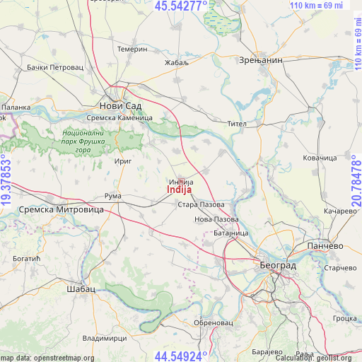
Inđija GPS coordinates[2]
45° 2' 53.376" North, 20° 4' 53.94" East
| Map corner | latitude | longitude |
|---|---|---|
| Upper-left | 45.54277°, | 19.37853° |
| Center: | 45.04816°, | 20.08165° |
| Lower-right: | 44.54924°, | 20.78478° |
| Map W x H: | 110.5×110.5 km | = 68.7×68.7mi |
| max Lat: | 46.1° ⇑39.9% North |
| Inđija: | 45.04816° |
| min Lat: | ⇓60.1% South 42.25846° |
| min Long | Inđija | max Long |
| 18.9276° | 20.08165° | 22.77556° |
| W 35.6%⇐ | ⇒64.4% E |
Elevation
Elevation of Inđija is 114 m = 374 ft, and this is 62.4 m = 205 ft below average elevation for this country.
| Max E: |
1421 m = 4662 ft | 38.8% |
| Avg. | 176.4 m = 579 ft | |
| Inđija | 114 m = 374 ft | |
Min E: |
49 m = 161 ft | 61.2% |
See also: Serbia elevation on elevation.city.
Geographical zone
Inđija is located in North temperate zone (between Tropic of Cancer and the Arctic Circle). Distance of this North polar circle is 2392.3 km =1486.5 mi to North.| Distance of | km | miles | from Inđija |
|---|---|---|---|
| North Pole | 4998.2 | 3105.7 | to North |
| Arctic Circle | 2392.3 | 1486.5 | to North |
| Tropic Cancer | 2403 | 1493.2 | to South |
| Equator | 5008.9 | 3112.4 | to South |


Nearby cities:
15 places around Inđija: (largest is in red/bold)
• Beška
9.3 km =5.8 mi,  352°
352°
• Gardinovci
17.8 km =11.1 mi,  13°
13°
• Golubinci
7.1 km =4.4 mi,  191°
191°
• Krčedin
10.8 km =6.7 mi,  21°
21°
• Ljukovo
4.9 km =3 mi,  240°
240°
• Nova Pazova
15.9 km =9.9 mi,  137°
137°
• Novi Karlovci
8.3 km =5.2 mi,  67°
67°
• Novi Slankamen
15.1 km =9.4 mi,  55°
55°
• Pećinci
17.9 km =11.1 mi,  210°
210°
• Putinci
10.7 km =6.6 mi,  234°
234°
• Stara Pazova
9.4 km =5.8 mi, 138°
• Stari Banovci
17.4 km =10.8 mi,  114°
114°
• Stari Slankamen
17.3 km =10.7 mi,  52°
52°
• Vojka
13.5 km =8.4 mi,  155°
155°
• Čortanovci
12.8 km =8 mi,  337°
337°
Sources, notices
• [Note1] Compared only with cities in Serbia existing in our database
• [Src1] Map data: © OpenStreetMap contributors (CC-BY-SA)
• [Src2] Other city data from geonames.org with taken over terms of usage.
• [Src3] Geographical zone / Annual Mean Temperature by Robert A. Rohde @ Wikipedia
