Pećinci geodata
Pećinci (Vojvodina) is a seat of a third-order administrative division; located in Serbia in Europe/Belgrade (GMT+2) time zone. With population of 2,232 people, there are 196 cities with bigger population in this country. Compared to other cities in Serbia, 53.3% of cities are located further ↓South; 69.2% of cities are located further →East and 58.5% of cities have higher elevation than Pećinci. Note1


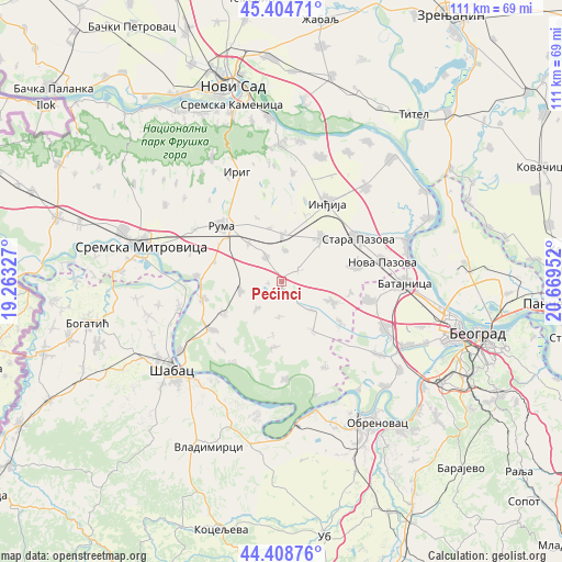
Pećinci GPS coordinates[2]
44° 54' 32.004" North, 19° 57' 59.004" East
| Map corner | latitude | longitude |
|---|---|---|
| Upper-left | 45.40471°, | 19.26327° |
| Center: | 44.90889°, | 19.96639° |
| Lower-right: | 44.40876°, | 20.66952° |
| Map W x H: | 110.7×110.7 km | = 68.8×68.8mi |
| max Lat: | 46.1° ⇑46.7% North |
| Pećinci: | 44.90889° |
| min Lat: | ⇓53.3% South 42.25846° |
| min Long | Pećinci | max Long |
| 18.9276° | 19.96639° | 22.77556° |
| W 30.8%⇐ | ⇒69.2% E |
Elevation
Elevation of Pećinci is 83 m = 272 ft, and this is 93.4 m = 306 ft below average elevation for this country.
| Max E: |
1421 m = 4662 ft | 58.5% |
| Avg. | 176.4 m = 579 ft | |
| Pećinci | 83 m = 272 ft | |
Min E: |
49 m = 161 ft | 41.5% |
See also: Serbia elevation on elevation.city.
Geographical zone
Pećinci is located in North temperate zone (between Tropic of Cancer and the Arctic Circle). Distance of this Northern Tropic circle is 2387.5 km =1483.5 mi to South.| Distance of | km | miles | from Pećinci |
|---|---|---|---|
| North Pole | 5013.7 | 3115.4 | to North |
| Arctic Circle | 2407.8 | 1496.1 | to North |
| Tropic Cancer | 2387.5 | 1483.5 | to South |
| Equator | 4993.4 | 3102.8 | to South |


Nearby cities:
15 places around Pećinci: (largest is in red/bold)
• Buđanovci
8.3 km =5.2 mi,  258°
258°
• Golubinci
11.4 km =7.1 mi,  41°
41°
• Hrtkovci
16.2 km =10.1 mi, 259°
• Inđija
17.9 km =11.1 mi,  30°
30°
• Irig
18.6 km =11.6 mi,  328°
328°
• Jarak
16.7 km =10.4 mi,  273°
273°
• Ljukovo
13.9 km =8.6 mi,  20°
20°
• Nikinci
13 km =8.1 mi,  239°
239°
• Platičevo
16.6 km =10.3 mi,  234°
234°
• Putinci
9.3 km =5.8 mi,  2°
2°
• Ruma
15.8 km =9.8 mi,  314°
314°
• Stara Pazova
17.5 km =10.9 mi,  61°
61°
• Ugrinovci
17.8 km =11.1 mi,  101°
101°
• Vojka
15 km =9.3 mi,  77°
77°
• Šimanovci
10.6 km =6.6 mi,  111°
111°
Sources, notices
• [Note1] Compared only with cities in Serbia existing in our database
• [Src1] Map data: © OpenStreetMap contributors (CC-BY-SA)
• [Src2] Other city data from geonames.org with taken over terms of usage.
• [Src3] Geographical zone / Annual Mean Temperature by Robert A. Rohde @ Wikipedia
