Ljukovo geodata
Ljukovo (Vojvodina) is a populated place; located in Serbia in Europe/Belgrade (GMT+2) time zone. With population of 1,191 people, there are 300 cities with bigger population in this country. Compared to other cities in Serbia, 59.2% of cities are located further ↓South; 67.8% of cities are located further →East and 57.1% of cities have lower elevation than Ljukovo. Note1


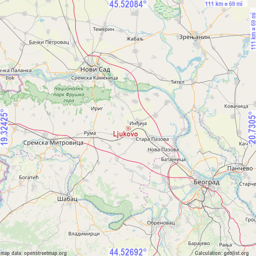
Ljukovo GPS coordinates[2]
45° 1' 33.744" North, 20° 1' 38.532" East
| Map corner | latitude | longitude |
|---|---|---|
| Upper-left | 45.52084°, | 19.32425° |
| Center: | 45.02604°, | 20.02737° |
| Lower-right: | 44.52692°, | 20.7305° |
| Map W x H: | 110.5×110.5 km | = 68.7×68.7mi |
| max Lat: | 46.1° ⇑40.8% North |
| Ljukovo: | 45.02604° |
| min Lat: | ⇓59.2% South 42.25846° |
| min Long | Ljukovo | max Long |
| 18.9276° | 20.02737° | 22.77556° |
| W 32.2%⇐ | ⇒67.8% E |
Elevation
Elevation of Ljukovo is 105 m = 344 ft, and this is 71.4 m = 234 ft below average elevation for this country.
| Max E: |
1421 m = 4662 ft | 42.9% |
| Avg. | 176.4 m = 579 ft | |
| Ljukovo | 105 m = 344 ft | |
Min E: |
49 m = 161 ft | 57.1% |
See also: Serbia elevation on elevation.city.
Geographical zone
Ljukovo is located in North temperate zone (between Tropic of Cancer and the Arctic Circle). Distance of this North polar circle is 2394.7 km =1488 mi to North.| Distance of | km | miles | from Ljukovo |
|---|---|---|---|
| North Pole | 5000.6 | 3107.2 | to North |
| Arctic Circle | 2394.7 | 1488 | to North |
| Tropic Cancer | 2400.5 | 1491.6 | to South |
| Equator | 5006.4 | 3110.8 | to South |


Nearby cities:
15 places around Ljukovo: (largest is in red/bold)
• Beška
12.1 km =7.5 mi,  14°
14°
• Golubinci
5.3 km =3.3 mi,  147°
147°
• Inđija
4.9 km =3 mi,  60°
60°
• Irig
14.7 km =9.1 mi,  281°
281°
• Irig
15.7 km =9.8 mi,  302°
302°
• Krčedin
15 km =9.3 mi,  33°
33°
• Nova Pazova
17.7 km =11 mi,  121°
121°
• Novi Karlovci
13.2 km =8.2 mi, 64°
• Pećinci
13.9 km =8.6 mi,  200°
200°
• Putinci
5.8 km =3.6 mi,  229°
229°
• Ruma
16.2 km =10.1 mi,  262°
262°
• Stara Pazova
11.4 km =7.1 mi,  113°
113°
• Vojka
13.9 km =8.6 mi,  135°
135°
• Čortanovci
14.3 km =8.9 mi,  357°
357°
• Šimanovci
17.7 km =11 mi,  163°
163°
Sources, notices
• [Note1] Compared only with cities in Serbia existing in our database
• [Src1] Map data: © OpenStreetMap contributors (CC-BY-SA)
• [Src2] Other city data from geonames.org with taken over terms of usage.
• [Src3] Geographical zone / Annual Mean Temperature by Robert A. Rohde @ Wikipedia
