Zima geodata
Zima (Irkutsk Oblast) is a populated place; located in Russia in Asia/Irkutsk (GMT+8) time zone. With population of 33,323 people, there are 602 cities with bigger population in this country. Compared to other cities in Russia, 56% of cities are located further ↑North; 88.6% of cities are located further ←West and 90.2% of cities have lower elevation than Zima. Note1


Zima GPS coordinates[2]
53° 55' 12.72" North, 102° 2' 39.12" East
| Map corner | latitude | longitude |
|---|---|---|
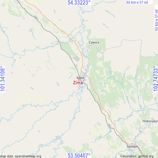
| Upper-left | 54.33223°, | 101.34108° |
| Center: | 53.9202°, | 102.0442° |
| Lower-right: | 53.50407°, | 102.74733° |
| Map W x H: | 92.1×92.1 km | = 57.2×57.2mi |
| max Lat: | 73.50819° ⇑56% North |
| Zima: | 53.9202° |
| min Lat: | ⇓44% South 41.28413° |
| min Long | Zima | max Long |
| -179.12198° | 102.0442° | 179.35046° |
| W 88.6%⇐ | ⇒11.4% E |
Elevation
Elevation of Zima is 454 m = 1490 ft, and this is 251.4 m = 825 ft above average elevation for this country.
| Max E: |
2518 m = 8261 ft | 9.8% |
| Zima | 454 m 1490 ft | |
| Avg. | 202.6 m = 665 ft | |
Min E: |
-28 m = -92 ft | 90.2% |
See also: Russia elevation on elevation.city.
Geographical zone
Zima is located in North temperate zone (between Tropic of Cancer and the Arctic Circle). Distance of this North polar circle is 1405.8 km =873.5 mi to North.| Distance of | km | miles | from Zima |
|---|---|---|---|
| North Pole | 4011.7 | 2492.8 | to North |
| Arctic Circle | 1405.8 | 873.5 | to North |
| Tropic Cancer | 3389.4 | 2106.1 | to South |
| Equator | 5995.4 | 3725.4 | to South |


Nearby cities:
15 places around Zima: (largest is in red/bold)
• Badar
108.4 km =67.4 mi,  299°
299°
• Balagansk
66.6 km =41.4 mi,  81°
81°
• Cheremkhovo
108.6 km =67.5 mi,  141°
141°
• Gadaley
100.4 km =62.4 mi, 302°
• Kimil’tey
24.1 km =15 mi,  350°
350°
• Kutulik
79.9 km =49.6 mi, 142°
• Kuytun
58.5 km =36.4 mi,  323°
323°
• Novonukutskiy
50.2 km =31.2 mi,  119°
119°
• Sayansk
22.4 km =13.9 mi,  20°
20°
• Sheragul
95.3 km =59.2 mi,  309°
309°
• Tulyushka
82.5 km =51.3 mi, 316°
• Tyret’ Pervaya
32.8 km =20.4 mi,  147°
147°
• Ust’-Uda
70.3 km =43.7 mi,  66°
66°
• Yevdokimova
98.2 km =61 mi,  293°
293°
• Zalari
50.4 km =31.3 mi, 142°
Sources, notices
• [Note1] Compared only with cities in Russia existing in our database
• [Src1] Map data: © OpenStreetMap contributors (CC-BY-SA)
• [Src2] Other city data from geonames.org with taken over terms of usage.
• [Src3] Geographical zone / Annual Mean Temperature by Robert A. Rohde @ Wikipedia
