Cheremkhovo geodata
Cheremkhovo (Irkutsk Oblast) is a populated place; located in Russia in Asia/Irkutsk (GMT+8) time zone. With population of 57,395 people, there are 366 cities with bigger population in this country. Compared to other cities in Russia, 61.7% of cities are located further ↑North; 88.8% of cities are located further ←West and 93.8% of cities have lower elevation than Cheremkhovo. Note1


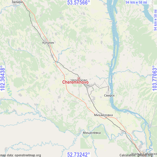
Cheremkhovo GPS coordinates[2]
53° 9' 21.996" North, 103° 4' 3" East
| Map corner | latitude | longitude |
|---|---|---|
| Upper-left | 53.57566°, | 102.36438° |
| Center: | 53.15611°, | 103.0675° |
| Lower-right: | 52.73242°, | 103.77063° |
| Map W x H: | 93.8×93.8 km | = 58.3×58.3mi |
| max Lat: | 73.50819° ⇑61.7% North |
| Cheremkhovo: | 53.15611° |
| min Lat: | ⇓38.3% South 41.28413° |
| min Long | Cheremkhovo | max Long |
| -179.12198° | 103.0675° | 179.35046° |
| W 88.8%⇐ | ⇒11.2% E |
Elevation
Elevation of Cheremkhovo is 573 m = 1880 ft, and this is 370.4 m = 1215 ft above average elevation for this country.
| Max E: |
2518 m = 8261 ft | 6.2% |
| Cheremkhovo | 573 m 1880 ft | |
| Avg. | 202.6 m = 665 ft | |
Min E: |
-28 m = -92 ft | 93.8% |
See also: Cheremkhovo elevation on elevation.city.
Geographical zone
Cheremkhovo is located in North temperate zone (between Tropic of Cancer and the Arctic Circle). Distance of this North polar circle is 1490.8 km =926.3 mi to North.| Distance of | km | miles | from Cheremkhovo |
|---|---|---|---|
| North Pole | 4096.7 | 2545.6 | to North |
| Arctic Circle | 1490.8 | 926.3 | to North |
| Tropic Cancer | 3304.5 | 2053.3 | to South |
| Equator | 5910.4 | 3672.6 | to South |


Nearby cities:
15 places around Cheremkhovo: (largest is in red/bold)
• Angarsk
88.1 km =54.7 mi,  141°
141°
• Balagansk
94.5 km =58.7 mi,  359°
359°
• Bokhan
46.9 km =29.1 mi,  90°
90°
• Kitoy
83.3 km =51.8 mi, 137°
• Kutulik
28.7 km =17.8 mi,  318°
318°
• Mishelevka
33.9 km =21.1 mi,  168°
168°
• Novonukutskiy
64.9 km =40.3 mi,  338°
338°
• Osa
59.6 km =37 mi,  64°
64°
• Sredniy
41.1 km =25.5 mi, 136°
• Svirsk
19.3 km =12 mi,  113°
113°
• Tayturka
41.4 km =25.7 mi, 140°
• Tel’ma
66.9 km =41.6 mi, 139°
• Tyret’ Pervaya
76.1 km =47.3 mi, 318°
• Usol’ye-Sibirskoye
59.3 km =36.8 mi, 139°
• Zalari
58.2 km =36.2 mi, 320°
Sources, notices
• [Note1] Compared only with cities in Russia existing in our database
• [Src1] Map data: © OpenStreetMap contributors (CC-BY-SA)
• [Src2] Other city data from geonames.org with taken over terms of usage.
• [Src3] Geographical zone / Annual Mean Temperature by Robert A. Rohde @ Wikipedia
