Preobrazheniye geodata
Preobrazheniye (Primorskiy (Maritime) Kray) is a populated place; located in Russia in Asia/Vladivostok (GMT+10) time zone. With population of 9,113 people, there are 1638 cities with bigger population in this country. Compared to other cities in Russia, 97.9% of cities are located further ↑North; 96.6% of cities are located further ←West and 89.8% of cities have higher elevation than Preobrazheniye. Note1


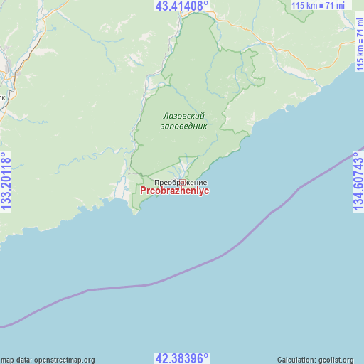
Preobrazheniye GPS coordinates[2]
42° 54' 4.212" North, 133° 54' 15.48" East
| Map corner | latitude | longitude |
|---|---|---|
| Upper-left | 43.41408°, | 133.20118° |
| Center: | 42.90117°, | 133.9043° |
| Lower-right: | 42.38396°, | 134.60743° |
| Map W x H: | 114.5×114.5 km | = 71.1×71.1mi |
| max Lat: | 73.50819° ⇑97.9% North |
| Preobrazheniye: | 42.90117° |
| min Lat: | ⇓2.1% South 41.28413° |
| min Long | Preobrazheniye | max Long |
| -179.12198° | 133.9043° | 179.35046° |
| W 96.6%⇐ | ⇒3.4% E |
Elevation
Elevation of Preobrazheniye is 29 m = 95 ft, and this is 173.6 m = 570 ft below average elevation for this country.
| Max E: |
2518 m = 8261 ft | 89.8% |
| Avg. | 202.6 m = 665 ft | |
| Preobrazheniye | 29 m = 95 ft | |
Min E: |
-28 m = -92 ft | 10.2% |
See also: Russia elevation on elevation.city.
Geographical zone
Preobrazheniye is located in North temperate zone (between Tropic of Cancer and the Arctic Circle). Distance of this Northern Tropic circle is 2164.2 km =1344.8 mi to South.| Distance of | km | miles | from Preobrazheniye |
|---|---|---|---|
| North Pole | 5236.9 | 3254.1 | to North |
| Arctic Circle | 2631 | 1634.8 | to North |
| Tropic Cancer | 2164.2 | 1344.8 | to South |
| Equator | 4770.2 | 2964.1 | to South |


Nearby cities:
15 places around Preobrazheniye: (largest is in red/bold)
• Dunay
127.8 km =79.4 mi,  268°
268°
• Fokino
122.3 km =76 mi, 273°
• Lazo
53.9 km =33.5 mi,  0°
0°
• Livadiya
100.3 km =62.3 mi, 267°
• Nakhodka
84.6 km =52.6 mi,  263°
263°
• Partizansk
68.1 km =42.3 mi,  291°
291°
• Putyatin
121.4 km =75.4 mi, 267°
• Romanovka
123.2 km =76.6 mi, 287°
• Sergeyevka
66.6 km =41.4 mi,  318°
318°
• Smolyaninovo
125.2 km =77.8 mi, 290°
• Uglekamensk
65.1 km =40.5 mi,  302°
302°
• Vladimiro-Aleksandrovskoye
67.3 km =41.8 mi, 269°
• Volchanets
93 km =57.8 mi, 270°
• Vrangel’
69.6 km =43.2 mi,  254°
254°
• Yekaterinovka
69.7 km =43.3 mi, 272°
Sources, notices
• [Note1] Compared only with cities in Russia existing in our database
• [Src1] Map data: © OpenStreetMap contributors (CC-BY-SA)
• [Src2] Other city data from geonames.org with taken over terms of usage.
• [Src3] Geographical zone / Annual Mean Temperature by Robert A. Rohde @ Wikipedia
