Ulan-Ude geodata
Ulan-Ude (Buryatiya Republic) is a seat of a first-order administrative division; located in Russia in Asia/Irkutsk (GMT+8) time zone. With population of 360,278 people, there are 49 cities with bigger population in this country. Compared to other cities in Russia, 70.3% of cities are located further ↑North; 90.6% of cities are located further ←West and 92.8% of cities have lower elevation than Ulan-Ude. Note1


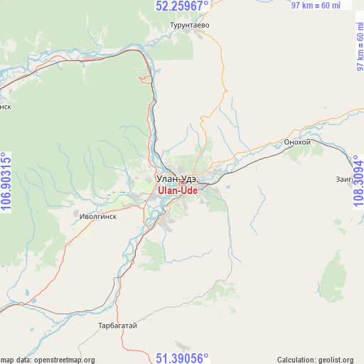
Ulan-Ude GPS coordinates[2]
51° 49' 37.956" North, 107° 36' 22.572" East
| Map corner | latitude | longitude |
|---|---|---|
| Upper-left | 52.25967°, | 106.90315° |
| Center: | 51.82721°, | 107.60627° |
| Lower-right: | 51.39056°, | 108.3094° |
| Map W x H: | 96.6×96.6 km | = 60×60mi |
| max Lat: | 73.50819° ⇑70.3% North |
| Ulan-Ude: | 51.82721° |
| min Lat: | ⇓29.7% South 41.28413° |
| min Long | Ulan-Ude | max Long |
| -179.12198° | 107.60627° | 179.35046° |
| W 90.6%⇐ | ⇒9.4% E |
Elevation
Elevation of Ulan-Ude is 528 m = 1732 ft, and this is 325.4 m = 1068 ft above average elevation for this country.
| Max E: |
2518 m = 8261 ft | 7.2% |
| Ulan-Ude | 528 m 1732 ft | |
| Avg. | 202.6 m = 665 ft | |
Min E: |
-28 m = -92 ft | 92.8% |
See also: Ulan-Ude elevation on elevation.city.
Geographical zone
Ulan-Ude is located in North temperate zone (between Tropic of Cancer and the Arctic Circle). Distance of this North polar circle is 1638.5 km =1018.1 mi to North.| Distance of | km | miles | from Ulan-Ude |
|---|---|---|---|
| North Pole | 4244.4 | 2637.3 | to North |
| Arctic Circle | 1638.5 | 1018.1 | to North |
| Tropic Cancer | 3156.7 | 1961.5 | to South |
| Equator | 5762.6 | 3580.7 | to South |


Nearby cities:
15 places around Ulan-Ude: (largest is in red/bold)
• Bol’shoy Kunaley
43.9 km =27.3 mi,  179°
179°
• Il’inka
39.8 km =24.7 mi,  324°
324°
• Ivolginsk
23.8 km =14.8 mi,  248°
248°
• Nikolayevskiy
23.3 km =14.5 mi,  145°
145°
• Nizhniy Sayantuy
11.9 km =7.4 mi,  212°
212°
• Novaya Bryan’
47.3 km =29.4 mi,  105°
105°
• Onokhoy
33.6 km =20.9 mi,  70°
70°
• Sokol
11.5 km =7.1 mi, 254°
• Sotnikovo
10.6 km =6.6 mi,  306°
306°
• Tarbagatay
41.9 km =26 mi,  203°
203°
• Tataurovo
36.8 km =22.9 mi,  342°
342°
• Turuntayevo
41.8 km =26 mi,  3°
3°
• Verkhnyaya Ivolga
29.5 km =18.3 mi, 253°
• Zaigrayevo
45.4 km =28.2 mi,  88°
88°
• Zarechnyy
6.4 km =4 mi,  292°
292°
Sources, notices
• [Note1] Compared only with cities in Russia existing in our database
• [Src1] Map data: © OpenStreetMap contributors (CC-BY-SA)
• [Src2] Other city data from geonames.org with taken over terms of usage.
• [Src3] Geographical zone / Annual Mean Temperature by Robert A. Rohde @ Wikipedia
