Turuntayevo geodata
Turuntayevo (Buryatiya Republic) is a populated place; located in Russia in Asia/Irkutsk (GMT+8) time zone. With population of 6,260 people, there are 2189 cities with bigger population in this country. Compared to other cities in Russia, 68% of cities are located further ↑North; 90.6% of cities are located further ←West and 92.4% of cities have lower elevation than Turuntayevo. Note1


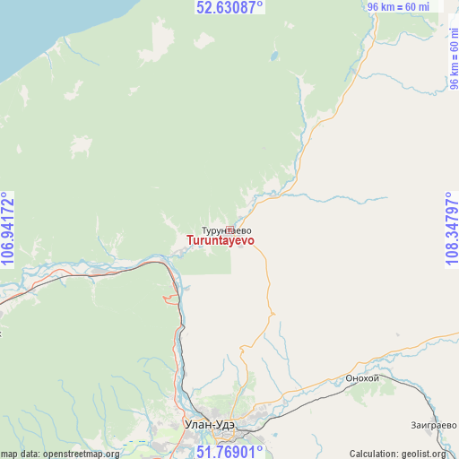
Turuntayevo GPS coordinates[2]
52° 12' 7.308" North, 107° 38' 41.424" East
| Map corner | latitude | longitude |
|---|---|---|
| Upper-left | 52.63087°, | 106.94172° |
| Center: | 52.20203°, | 107.64484° |
| Lower-right: | 51.76901°, | 108.34797° |
| Map W x H: | 95.8×95.8 km | = 59.5×59.5mi |
| max Lat: | 73.50819° ⇑68% North |
| Turuntayevo: | 52.20203° |
| min Lat: | ⇓32% South 41.28413° |
| min Long | Turuntayevo | max Long |
| -179.12198° | 107.64484° | 179.35046° |
| W 90.6%⇐ | ⇒9.4% E |
Elevation
Elevation of Turuntayevo is 518 m = 1699 ft, and this is 315.4 m = 1035 ft above average elevation for this country.
| Max E: |
2518 m = 8261 ft | 7.6% |
| Turuntayevo | 518 m 1699 ft | |
| Avg. | 202.6 m = 665 ft | |
Min E: |
-28 m = -92 ft | 92.4% |
See also: Russia elevation on elevation.city.
Geographical zone
Turuntayevo is located in North temperate zone (between Tropic of Cancer and the Arctic Circle). Distance of this North polar circle is 1596.9 km =992.3 mi to North.| Distance of | km | miles | from Turuntayevo |
|---|---|---|---|
| North Pole | 4202.7 | 2611.4 | to North |
| Arctic Circle | 1596.9 | 992.3 | to North |
| Tropic Cancer | 3198.4 | 1987.4 | to South |
| Equator | 5804.3 | 3606.6 | to South |


Nearby cities:
15 places around Turuntayevo: (largest is in red/bold)
• Il’inka
27.1 km =16.8 mi,  250°
250°
• Il’ka
80.4 km =50 mi,  131°
131°
• Ivolginsk
56.1 km =34.9 mi,  206°
206°
• Kabansk
69.8 km =43.4 mi,  255°
255°
• Nikolayevskiy
61.7 km =38.3 mi,  170°
170°
• Nizhniy Sayantuy
52.4 km =32.6 mi,  189°
189°
• Novaya Bryan’
68.9 km =42.8 mi,  141°
141°
• Onokhoy
41.9 km =26 mi, 136°
• Sokol
46.7 km =29 mi,  197°
197°
• Sotnikovo
37 km =23 mi, 197°
• Tataurovo
15.5 km =9.6 mi,  244°
244°
• Ulan-Ude
41.8 km =26 mi,  183°
183°
• Verkhnyaya Ivolga
58.8 km =36.5 mi, 211°
• Zaigrayevo
59 km =36.7 mi, 133°
• Zarechnyy
40.1 km =24.9 mi, 192°
Sources, notices
• [Note1] Compared only with cities in Russia existing in our database
• [Src1] Map data: © OpenStreetMap contributors (CC-BY-SA)
• [Src2] Other city data from geonames.org with taken over terms of usage.
• [Src3] Geographical zone / Annual Mean Temperature by Robert A. Rohde @ Wikipedia
