Zaigrayevo geodata
Zaigrayevo (Buryatiya Republic) is a populated place; located in Russia in Asia/Irkutsk (GMT+8) time zone. With population of 5,512 people, there are 2435 cities with bigger population in this country. Compared to other cities in Russia, 70.2% of cities are located further ↑North; 90.9% of cities are located further ←West and 94% of cities have lower elevation than Zaigrayevo. Note1


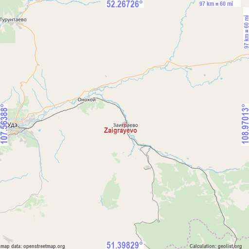
Zaigrayevo GPS coordinates[2]
51° 50' 5.532" North, 108° 16' 1.2" East
| Map corner | latitude | longitude |
|---|---|---|
| Upper-left | 52.26726°, | 107.56388° |
| Center: | 51.83487°, | 108.267° |
| Lower-right: | 51.39829°, | 108.97013° |
| Map W x H: | 96.6×96.6 km | = 60×60mi |
| max Lat: | 73.50819° ⇑70.2% North |
| Zaigrayevo: | 51.83487° |
| min Lat: | ⇓29.8% South 41.28413° |
| min Long | Zaigrayevo | max Long |
| -179.12198° | 108.267° | 179.35046° |
| W 90.9%⇐ | ⇒9.1% E |
Elevation
Elevation of Zaigrayevo is 580 m = 1903 ft, and this is 377.4 m = 1238 ft above average elevation for this country.
| Max E: |
2518 m = 8261 ft | 6% |
| Zaigrayevo | 580 m 1903 ft | |
| Avg. | 202.6 m = 665 ft | |
Min E: |
-28 m = -92 ft | 94% |
See also: Russia elevation on elevation.city.
Geographical zone
Zaigrayevo is located in North temperate zone (between Tropic of Cancer and the Arctic Circle). Distance of this North polar circle is 1637.7 km =1017.6 mi to North.| Distance of | km | miles | from Zaigrayevo |
|---|---|---|---|
| North Pole | 4243.6 | 2636.8 | to North |
| Arctic Circle | 1637.7 | 1017.6 | to North |
| Tropic Cancer | 3157.6 | 1962 | to South |
| Equator | 5763.5 | 3581.3 | to South |


Nearby cities:
15 places around Zaigrayevo: (largest is in red/bold)
• Bol’shoy Kunaley
63.8 km =39.6 mi,  225°
225°
• Il’ka
21.6 km =13.4 mi,  125°
125°
• Ivolginsk
68.3 km =42.4 mi,  261°
261°
• Nikolayevskiy
37.8 km =23.5 mi,  238°
238°
• Nikol’sk
72 km =44.7 mi,  176°
176°
• Nizhniy Sayantuy
53 km =32.9 mi, 258°
• Novaya Bryan’
13.1 km =8.1 mi, 179°
• Onokhoy
17.2 km =10.7 mi,  307°
307°
• Sagan-Nur
56 km =34.8 mi,  167°
167°
• Sokol
56.7 km =35.2 mi,  266°
266°
• Sotnikovo
54.2 km =33.7 mi,  275°
275°
• Tataurovo
66.1 km =41.1 mi,  301°
301°
• Turuntayevo
59 km =36.7 mi, 313°
• Ulan-Ude
45.4 km =28.2 mi, 268°
• Zarechnyy
51.3 km =31.9 mi, 271°
Sources, notices
• [Note1] Compared only with cities in Russia existing in our database
• [Src1] Map data: © OpenStreetMap contributors (CC-BY-SA)
• [Src2] Other city data from geonames.org with taken over terms of usage.
• [Src3] Geographical zone / Annual Mean Temperature by Robert A. Rohde @ Wikipedia
