Sotnikovo geodata
Sotnikovo (Buryatiya Republic) is a populated place; located in Russia in Asia/Irkutsk (GMT+8) time zone. With population of 4,396 people, there are 2912 cities with bigger population in this country. Compared to other cities in Russia, 69.8% of cities are located further ↑North; 90.5% of cities are located further ←West and 91.9% of cities have lower elevation than Sotnikovo. Note1


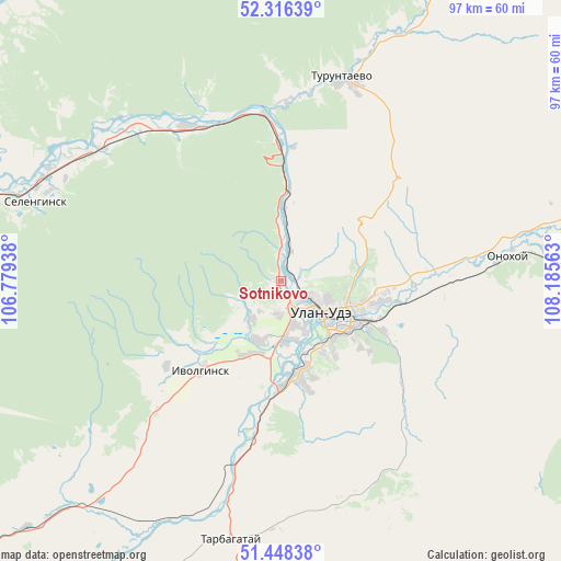
Sotnikovo GPS coordinates[2]
51° 53' 4.128" North, 107° 28' 57" East
| Map corner | latitude | longitude |
|---|---|---|
| Upper-left | 52.31639°, | 106.77938° |
| Center: | 51.88448°, | 107.4825° |
| Lower-right: | 51.44838°, | 108.18563° |
| Map W x H: | 96.5×96.5 km | = 60×60mi |
| max Lat: | 73.50819° ⇑69.8% North |
| Sotnikovo: | 51.88448° |
| min Lat: | ⇓30.2% South 41.28413° |
| min Long | Sotnikovo | max Long |
| -179.12198° | 107.4825° | 179.35046° |
| W 90.5%⇐ | ⇒9.5% E |
Elevation
Elevation of Sotnikovo is 499 m = 1637 ft, and this is 296.4 m = 972 ft above average elevation for this country.
| Max E: |
2518 m = 8261 ft | 8.1% |
| Sotnikovo | 499 m 1637 ft | |
| Avg. | 202.6 m = 665 ft | |
Min E: |
-28 m = -92 ft | 91.9% |
See also: Russia elevation on elevation.city.
Geographical zone
Sotnikovo is located in North temperate zone (between Tropic of Cancer and the Arctic Circle). Distance of this North polar circle is 1632.2 km =1014.2 mi to North.| Distance of | km | miles | from Sotnikovo |
|---|---|---|---|
| North Pole | 4238 | 2633.4 | to North |
| Arctic Circle | 1632.2 | 1014.2 | to North |
| Tropic Cancer | 3163.1 | 1965.5 | to South |
| Equator | 5769 | 3584.7 | to South |


Nearby cities:
15 places around Sotnikovo: (largest is in red/bold)
• Bol’shoy Kunaley
51.1 km =31.8 mi,  170°
170°
• Il’inka
29.9 km =18.6 mi,  330°
330°
• Ivolginsk
20.3 km =12.6 mi,  222°
222°
• Nikolayevskiy
33.6 km =20.9 mi,  139°
139°
• Nizhniy Sayantuy
16.5 km =10.3 mi, 172°
• Novaya Bryan’
57.3 km =35.6 mi,  108°
108°
• Onokhoy
40.4 km =25.1 mi,  83°
83°
• Sokol
9.7 km =6 mi,  195°
195°
• Tarbagatay
45.5 km =28.3 mi,  190°
190°
• Tataurovo
28.8 km =17.9 mi,  354°
354°
• Turuntayevo
37 km =23 mi,  17°
17°
• Ulan-Ude
10.6 km =6.6 mi,  126°
126°
• Verkhnyaya Ivolga
24.6 km =15.3 mi,  233°
233°
• Zaigrayevo
54.2 km =33.7 mi,  95°
95°
• Zarechnyy
4.7 km =2.9 mi,  145°
145°
Sources, notices
• [Note1] Compared only with cities in Russia existing in our database
• [Src1] Map data: © OpenStreetMap contributors (CC-BY-SA)
• [Src2] Other city data from geonames.org with taken over terms of usage.
• [Src3] Geographical zone / Annual Mean Temperature by Robert A. Rohde @ Wikipedia
