Lazo geodata
Lazo (Primorskiy (Maritime) Kray) is a populated place; located in Russia in Asia/Vladivostok (GMT+10) time zone. With population of 3,551 people, there are 3373 cities with bigger population in this country. Compared to other cities in Russia, 94.7% of cities are located further ↑North; 96.6% of cities are located further ←West and 78.2% of cities have lower elevation than Lazo. Note1


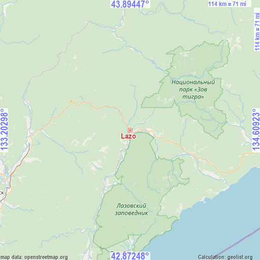
Lazo GPS coordinates[2]
43° 23' 8.268" North, 133° 54' 21.96" East
| Map corner | latitude | longitude |
|---|---|---|
| Upper-left | 43.89447°, | 133.20298° |
| Center: | 43.38563°, | 133.9061° |
| Lower-right: | 42.87248°, | 134.60923° |
| Map W x H: | 113.6×113.6 km | = 70.6×70.6mi |
| max Lat: | 73.50819° ⇑94.7% North |
| Lazo: | 43.38563° |
| min Lat: | ⇓5.3% South 41.28413° |
| min Long | Lazo | max Long |
| -179.12198° | 133.9061° | 179.35046° |
| W 96.6%⇐ | ⇒3.4% E |
Elevation
Elevation of Lazo is 236 m = 774 ft, and this is 33.4 m = 110 ft above average elevation for this country.
| Max E: |
2518 m = 8261 ft | 21.8% |
| Lazo | 236 m 774 ft | |
| Avg. | 202.6 m = 665 ft | |
Min E: |
-28 m = -92 ft | 78.2% |
See also: Russia elevation on elevation.city.
Geographical zone
Lazo is located in North temperate zone (between Tropic of Cancer and the Arctic Circle). Distance of this Northern Tropic circle is 2218.1 km =1378.3 mi to South.| Distance of | km | miles | from Lazo |
|---|---|---|---|
| North Pole | 5183 | 3220.6 | to North |
| Arctic Circle | 2577.1 | 1601.3 | to North |
| Tropic Cancer | 2218.1 | 1378.3 | to South |
| Equator | 4824 | 2997.5 | to South |


Nearby cities:
15 places around Lazo: (largest is in red/bold)
• Anuchino
93.8 km =58.3 mi,  313°
313°
• Arsen’yev
99.1 km =61.6 mi,  329°
329°
• Chernyshëvka
109.8 km =68.2 mi, 325°
• Chuguyevka
86.9 km =54 mi,  357°
357°
• Grazhdanka
109.3 km =67.9 mi, 327°
• Nakhodka
105.2 km =65.4 mi,  232°
232°
• Novosysoyevka
103.9 km =64.6 mi,  335°
335°
• Partizansk
69.8 km =43.4 mi,  245°
245°
• Preobrazheniye
53.9 km =33.5 mi,  180°
180°
• Sergeyevka
44.4 km =27.6 mi,  264°
264°
• Uglekamensk
57.6 km =35.8 mi, 251°
• Vladimiro-Aleksandrovskoye
86.8 km =53.9 mi, 230°
• Volchanets
106.6 km =66.2 mi,  240°
240°
• Vrangel’
98.9 km =61.5 mi,  222°
222°
• Yekaterinovka
86.3 km =53.6 mi, 233°
Sources, notices
• [Note1] Compared only with cities in Russia existing in our database
• [Src1] Map data: © OpenStreetMap contributors (CC-BY-SA)
• [Src2] Other city data from geonames.org with taken over terms of usage.
• [Src3] Geographical zone / Annual Mean Temperature by Robert A. Rohde @ Wikipedia
