Tayturka geodata
Tayturka (Irkutsk Oblast) is a populated place; located in Russia in Asia/Irkutsk (GMT+8) time zone. With population of 5,100 people, there are 2611 cities with bigger population in this country. Compared to other cities in Russia, 63.6% of cities are located further ↑North; 89% of cities are located further ←West and 88.5% of cities have lower elevation than Tayturka. Note1


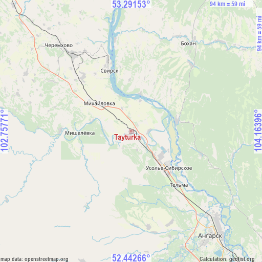
Tayturka GPS coordinates[2]
52° 52' 9.012" North, 103° 27' 38.988" East
| Map corner | latitude | longitude |
|---|---|---|
| Upper-left | 53.29153°, | 102.75771° |
| Center: | 52.86917°, | 103.46083° |
| Lower-right: | 52.44266°, | 104.16396° |
| Map W x H: | 94.4×94.4 km | = 58.7×58.7mi |
| max Lat: | 73.50819° ⇑63.6% North |
| Tayturka: | 52.86917° |
| min Lat: | ⇓36.4% South 41.28413° |
| min Long | Tayturka | max Long |
| -179.12198° | 103.46083° | 179.35046° |
| W 89%⇐ | ⇒11% E |
Elevation
Elevation of Tayturka is 410 m = 1345 ft, and this is 207.4 m = 680 ft above average elevation for this country.
| Max E: |
2518 m = 8261 ft | 11.5% |
| Tayturka | 410 m 1345 ft | |
| Avg. | 202.6 m = 665 ft | |
Min E: |
-28 m = -92 ft | 88.5% |
See also: Russia elevation on elevation.city.
Geographical zone
Tayturka is located in North temperate zone (between Tropic of Cancer and the Arctic Circle). Distance of this North polar circle is 1522.7 km =946.2 mi to North.| Distance of | km | miles | from Tayturka |
|---|---|---|---|
| North Pole | 4128.6 | 2565.4 | to North |
| Arctic Circle | 1522.7 | 946.2 | to North |
| Tropic Cancer | 3272.6 | 2033.5 | to South |
| Equator | 5878.5 | 3652.7 | to South |


Nearby cities:
15 places around Tayturka: (largest is in red/bold)
• Angarsk
46.8 km =29.1 mi,  142°
142°
• Bokhan
37.8 km =23.5 mi,  33°
33°
• Cheremkhovo
41.4 km =25.7 mi,  320°
320°
• Khomutovo
77.7 km =48.3 mi,  125°
125°
• Kitoy
42.1 km =26.2 mi, 135°
• Kutulik
70.1 km =43.6 mi, 319°
• Meget
64.2 km =39.9 mi, 141°
• Mishelevka
19.4 km =12.1 mi,  266°
266°
• Osa
63.9 km =39.7 mi, 25°
• Oyëk
74 km =46 mi,  115°
115°
• Sredniy
2.9 km =1.8 mi,  42°
42°
• Svirsk
25.6 km =15.9 mi,  340°
340°
• Tel’ma
25.5 km =15.8 mi, 138°
• Urik
69.5 km =43.2 mi, 130°
• Usol’ye-Sibirskoye
18 km =11.2 mi, 136°
Sources, notices
• [Note1] Compared only with cities in Russia existing in our database
• [Src1] Map data: © OpenStreetMap contributors (CC-BY-SA)
• [Src2] Other city data from geonames.org with taken over terms of usage.
• [Src3] Geographical zone / Annual Mean Temperature by Robert A. Rohde @ Wikipedia
