Osa geodata
Osa (Irkutsk Oblast) is a populated place; located in Russia in Asia/Irkutsk (GMT+8) time zone. With population of 4,454 people, there are 2886 cities with bigger population in this country. Compared to other cities in Russia, 59.6% of cities are located further ↑North; 89.2% of cities are located further ←West and 89% of cities have lower elevation than Osa. Note1


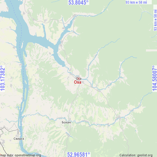
Osa GPS coordinates[2]
53° 23' 13.992" North, 103° 52' 36.984" East
| Map corner | latitude | longitude |
|---|---|---|
| Upper-left | 53.8045°, | 103.17382° |
| Center: | 53.38722°, | 103.87694° |
| Lower-right: | 52.96581°, | 104.58007° |
| Map W x H: | 93.3×93.3 km | = 58×58mi |
| max Lat: | 73.50819° ⇑59.6% North |
| Osa: | 53.38722° |
| min Lat: | ⇓40.4% South 41.28413° |
| min Long | Osa | max Long |
| -179.12198° | 103.87694° | 179.35046° |
| W 89.2%⇐ | ⇒10.8% E |
Elevation
Elevation of Osa is 428 m = 1404 ft, and this is 225.4 m = 740 ft above average elevation for this country.
| Max E: |
2518 m = 8261 ft | 11% |
| Osa | 428 m 1404 ft | |
| Avg. | 202.6 m = 665 ft | |
Min E: |
-28 m = -92 ft | 89% |
See also: Russia elevation on elevation.city.
Geographical zone
Osa is located in North temperate zone (between Tropic of Cancer and the Arctic Circle). Distance of this North polar circle is 1465.1 km =910.4 mi to North.| Distance of | km | miles | from Osa |
|---|---|---|---|
| North Pole | 4071 | 2529.6 | to North |
| Arctic Circle | 1465.1 | 910.4 | to North |
| Tropic Cancer | 3330.2 | 2069.3 | to South |
| Equator | 5936.1 | 3688.5 | to South |


Nearby cities:
15 places around Osa: (largest is in red/bold)
• Angarsk
94.6 km =58.8 mi,  179°
179°
• Balagansk
87.6 km =54.4 mi,  321°
321°
• Bokhan
27 km =16.8 mi,  195°
195°
• Cheremkhovo
59.6 km =37 mi,  244°
244°
• Kitoy
87.5 km =54.4 mi, 178°
• Kutulik
72.6 km =45.1 mi,  266°
266°
• Mishelevka
75.4 km =46.9 mi,  218°
218°
• Novonukutskiy
84.5 km =52.5 mi,  294°
294°
• Sredniy
61.2 km =38 mi, 204°
• Svirsk
49.4 km =30.7 mi,  227°
227°
• Tayturka
63.9 km =39.7 mi,  205°
205°
• Tel’ma
77.4 km =48.1 mi,  188°
188°
• Usol’ye-Sibirskoye
72.3 km =44.9 mi, 192°
• Ust’-Ordynskiy
87.1 km =54.1 mi,  137°
137°
• Zalari
92.7 km =57.6 mi,  281°
281°
Sources, notices
• [Note1] Compared only with cities in Russia existing in our database
• [Src1] Map data: © OpenStreetMap contributors (CC-BY-SA)
• [Src2] Other city data from geonames.org with taken over terms of usage.
• [Src3] Geographical zone / Annual Mean Temperature by Robert A. Rohde @ Wikipedia
