Mukhorshibir’ geodata
Mukhorshibir’ (Buryatiya Republic) is a populated place; located in Russia in Asia/Irkutsk (GMT+8) time zone. With population of 5,500 people, there are 2440 cities with bigger population in this country. Compared to other cities in Russia, 74.7% of cities are located further ↑North; 90.7% of cities are located further ←West and 96.7% of cities have lower elevation than Mukhorshibir’. Note1


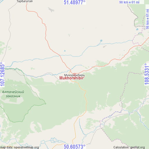
Mukhorshibir’ GPS coordinates[2]
51° 2' 59.496" North, 107° 49' 47.892" East
| Map corner | latitude | longitude |
|---|---|---|
| Upper-left | 51.48977°, | 107.12685° |
| Center: | 51.04986°, | 107.82997° |
| Lower-right: | 50.60573°, | 108.5331° |
| Map W x H: | 98.3×98.3 km | = 61.1×61.1mi |
| max Lat: | 73.50819° ⇑74.7% North |
| Mukhorshibir’: | 51.04986° |
| min Lat: | ⇓25.3% South 41.28413° |
| min Long | Mukhorshibir’ | max Long |
| -179.12198° | 107.82997° | 179.35046° |
| W 90.7%⇐ | ⇒9.3% E |
Elevation
Elevation of Mukhorshibir’ is 742 m = 2434 ft, and this is 539.4 m = 1770 ft above average elevation for this country.
| Max E: |
2518 m = 8261 ft | 3.3% |
| Mukhorshibir’ | 742 m 2434 ft | |
| Avg. | 202.6 m = 665 ft | |
Min E: |
-28 m = -92 ft | 96.7% |
See also: Russia elevation on elevation.city.
Geographical zone
Mukhorshibir’ is located in North temperate zone (between Tropic of Cancer and the Arctic Circle). Distance of this North polar circle is 1725 km =1071.9 mi to North.| Distance of | km | miles | from Mukhorshibir’ |
|---|---|---|---|
| North Pole | 4330.8 | 2691 | to North |
| Arctic Circle | 1725 | 1071.9 | to North |
| Tropic Cancer | 3070.3 | 1907.8 | to South |
| Equator | 5676.2 | 3527 | to South |


Nearby cities:
15 places around Mukhorshibir’: (largest is in red/bold)
• Balyaga
77.5 km =48.2 mi,  81°
81°
• Bichura
53.8 km =33.4 mi,  197°
197°
• Bol’shoy Kunaley
45.2 km =28.1 mi,  340°
340°
• Gashey
32.1 km =19.9 mi,  267°
267°
• Khonkholoy
29.1 km =18.1 mi,  71°
71°
• Nikolayevskiy
67.3 km =41.8 mi,  358°
358°
• Nikol’sk
37.6 km =23.4 mi, 65°
• Nizhniy Sayantuy
79.6 km =49.5 mi, 343°
• Novosretenka
38.2 km =23.7 mi, 195°
• Novyy Zagan
5.2 km =3.2 mi,  242°
242°
• Okino-Klyuchi
71.6 km =44.5 mi,  224°
224°
• Petrovsk-Zabaykal’skiy
75 km =46.6 mi, 70°
• Sagan-Nur
53.9 km =33.5 mi,  52°
52°
• Sharalday
13.2 km =8.2 mi,  258°
258°
• Tarbagatay
58.1 km =36.1 mi,  325°
325°
Sources, notices
• [Note1] Compared only with cities in Russia existing in our database
• [Src1] Map data: © OpenStreetMap contributors (CC-BY-SA)
• [Src2] Other city data from geonames.org with taken over terms of usage.
• [Src3] Geographical zone / Annual Mean Temperature by Robert A. Rohde @ Wikipedia
