Sharalday geodata
Sharalday (Buryatiya Republic) is a populated place; located in Russia in Asia/Irkutsk (GMT+8) time zone. With population of 1,600 people, there are 4336 cities with bigger population in this country. Compared to other cities in Russia, 74.8% of cities are located further ↑North; 90.7% of cities are located further ←West and 95.8% of cities have lower elevation than Sharalday. Note1


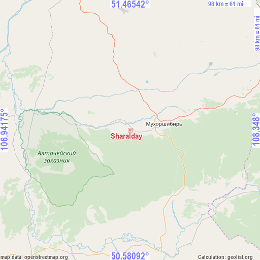
Sharalday GPS coordinates[2]
51° 1' 31.008" North, 107° 38' 41.532" East
| Map corner | latitude | longitude |
|---|---|---|
| Upper-left | 51.46542°, | 106.94175° |
| Center: | 51.02528°, | 107.64487° |
| Lower-right: | 50.58092°, | 108.348° |
| Map W x H: | 98.3×98.3 km | = 61.1×61.1mi |
| max Lat: | 73.50819° ⇑74.8% North |
| Sharalday: | 51.02528° |
| min Lat: | ⇓25.2% South 41.28413° |
| min Long | Sharalday | max Long |
| -179.12198° | 107.64487° | 179.35046° |
| W 90.7%⇐ | ⇒9.3% E |
Elevation
Elevation of Sharalday is 686 m = 2251 ft, and this is 483.4 m = 1586 ft above average elevation for this country.
| Max E: |
2518 m = 8261 ft | 4.2% |
| Sharalday | 686 m 2251 ft | |
| Avg. | 202.6 m = 665 ft | |
Min E: |
-28 m = -92 ft | 95.8% |
See also: Russia elevation on elevation.city.
Geographical zone
Sharalday is located in North temperate zone (between Tropic of Cancer and the Arctic Circle). Distance of this North polar circle is 1727.7 km =1073.5 mi to North.| Distance of | km | miles | from Sharalday |
|---|---|---|---|
| North Pole | 4333.6 | 2692.8 | to North |
| Arctic Circle | 1727.7 | 1073.5 | to North |
| Tropic Cancer | 3067.6 | 1906.1 | to South |
| Equator | 5673.5 | 3525.3 | to South |


Nearby cities:
15 places around Sharalday: (largest is in red/bold)
• Bichura
48.7 km =30.3 mi,  183°
183°
• Bol’shoy Kunaley
45.3 km =28.1 mi,  356°
356°
• Gashey
19.2 km =11.9 mi,  274°
274°
• Gusinoozyorsk
84.8 km =52.7 mi,  289°
289°
• Ivolginsk
84.3 km =52.4 mi,  342°
342°
• Khonkholoy
42.2 km =26.2 mi,  73°
73°
• Mukhorshibir’
13.2 km =8.2 mi,  78°
78°
• Nikolayevskiy
70.9 km =44.1 mi,  8°
8°
• Nikol’sk
50.6 km =31.4 mi, 68°
• Nizhniy Sayantuy
79.7 km =49.5 mi,  353°
353°
• Novosretenka
34.3 km =21.3 mi, 175°
• Novyy Zagan
8.3 km =5.2 mi,  87°
87°
• Okino-Klyuchi
61 km =37.9 mi,  218°
218°
• Sagan-Nur
66 km =41 mi,  57°
57°
• Tarbagatay
54.5 km =33.9 mi, 338°
Sources, notices
• [Note1] Compared only with cities in Russia existing in our database
• [Src1] Map data: © OpenStreetMap contributors (CC-BY-SA)
• [Src2] Other city data from geonames.org with taken over terms of usage.
• [Src3] Geographical zone / Annual Mean Temperature by Robert A. Rohde @ Wikipedia
